Askersund
 Askersund | |||
| |||
| Państwo | |||
|---|---|---|---|
| Region | |||
| Gmina | Askersund | ||
| Powierzchnia | 3,86[1] km² | ||
| Populacja (2018) • liczba ludności • gęstość | 4172[1] 1081[1] os./km² | ||
| Nr kierunkowy | (+46) 583 | ||
| Kod pocztowy | 696 xx | ||
| Strona internetowa | |||
| Portal | |||

Askersund – miejscowość (tätort) w Szwecji, w regionie administracyjnym (län) Örebro. Siedziba władz (centralort) gminy Askersund. W latach 1643-1970 Askersund posiadało status miasta.
Miejscowość położona jest w południowej części prowincji historycznej (landskap) Närke, ok. 50 km na południe od Örebro nad północnym krańcem jeziora Wetter. Przez Askersund przebiega droga krajowa nr 50 (Riksväg 50; (Jönköping) – Örebro – Bollnäs) i ma swój początek droga krajowa nr 49 (Riksväg 49) do Skara.
Askersund i jego okolice stanowiły w średniowieczu ważne centrum wydobycia i produkcji żelaza. 13 czerwca 1643 r. Askersund otrzymał prawa miejskie[2].
W 2010 r. Askersund liczył 3887 mieszkańców[3].
Przypisy
- ↑ a b c Statistiska tätorter 2018; befolkning, landareal, befolkningstäthet (szw.). Statistikmyndigheten SCB, 2020-03-20. [dostęp 2020-09-08]. [zarchiwizowane z tego adresu (2020-03-24)].
- ↑ Askersunds kommun: Askersunds historia (szw.). [dostęp 2014-07-22].
- ↑ Statistiska centralbyrån: Tätorter; arealer, befolkning. Tätorter 2010 (szw.). [dostęp 2014-07-26].
Media użyte na tej stronie
(c) Lokal_Profil, CC BY-SA 2.5
This coat of arms was drawn based on its blazon which – being a written description – is free from copyright. Any illustration conforming with the blazon of the arms is considered to be heraldically correct. Thus several different artistic interpretations of the same coat of arms can exist. The design officially used by the armiger is likely protected by copyright, in which case it cannot be used here.
Individual representations of a coat of arms, drawn from a blazon, may have a copyright belonging to the artist, but are not necessarily derivative works.
Autor: Erik Frohne, Licencja: CC BY 3.0
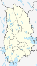
Location map of Örebro County in Sweden
Equirectangular projection, N/S stretching 196 %. Geographic limits of the map:
- N: 60.20° N
- S: 58.60° N
- W: 14.10° E
- E: 15.90° E


