Asten (Holandia)
 | |||||
| Państwo | |||||
|---|---|---|---|---|---|
| Prowincja | |||||
| Burmistrz | Hubert Vos (2014)[1] | ||||
| Powierzchnia | 70,34 km² | ||||
| Populacja (30.04.2017) • liczba ludności • gęstość | 16 658 237 os./km² | ||||
| Kod pocztowy | 5720–5725 | ||||
 | |||||
| Strona internetowa | |||||
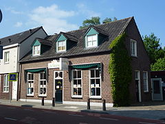
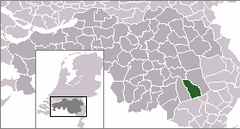
Asten – miasto w południowej Holandii, w północnej Brabancji.
Znajduje się tu ludwisarnia Royal Eijsbouts i muzeum carillonów.
Przypisy
- ↑ asten.nl: College van burgemeester en wethouders (niderl.). [dostęp 2014-07-13]. [zarchiwizowane z tego adresu (2014-04-26)].
Linki zewnętrzne
Media użyte na tej stronie
Flag of the Dutch municipality of Asten
Autor: Erik Frohne, Licencja: CC BY-SA 3.0
Location map of province North Brabant in the Netherlands
Equirectangular projection, N/S stretching 161 %. Geographic limits of the map:
- N: 51.90° N
- S: 51.20° N
- W: 4.10° E
- E: 6.10° E
Coats of arms of municipalitie of Asten


