Atchafalaya
 Delta rzeki Atchafalaya | |
| Kontynent | |
|---|---|
| Państwo | |
| Lokalizacja | |
| Rzeka | |
| Długość | 273[1] km |
| Powierzchnia zlewni | 150 737 km² |
| Średni przepływ | 5748[2] m³/s Simmesport, Luizjana |
| Źródło | |
| Miejsce | Turnbull Island[3] |
| Współrzędne | |
| Ujście | |
| Recypient | |
| Miejsce | Morgan City[4] |
| Wysokość | 0 |
| Mapa | |
 | |
Atchafalaya River – rzeka w Stanach Zjednoczonych Ameryki Północnej, przepływająca przez stan Luizjana, będąca odnogą rzeki Missisipi.
Długość Atchafalaya River to 273 kilometry (170 mil), a powierzchnia dorzecza wynosi 150,7 tysięcy km². Źródło rzeki jest umowne i przyjmuje się że jest w pobliżu południowo-zachodniego krańca wyspy Turnbull, utworzonej pomiędzy Missisipi, Red River oraz starym zakolem Missisipi nazywanym Old River[1]
Nazwa rzeki pochodzi od połączenia słów z języka Indian Czoktawów oznaczających długa rzeka (hacha – rzeka oraz falaia – długa)[5].
Rzeka jest na całej długości żeglowna i według danych USA Navigation Data Center w Waterborne w 2009 roku przewieziono rzeką ponad 13,6 miliona ton towarów[1]. Budową obiektów wodnych oraz utrzymywaniem żeglowności od ponad 100 lat zajmuje się Korpus Inżynieryjny Armii Stanów Zjednoczonych[4][1]. W 1984 roku na terenach otaczających rzekę oraz w delcie pomiędzy Atchafalaya a Missisipi na terenach nazywanych Bagna Atchafalaya (ang. Atchafalaya Swamp), które są największym obszarem bagien w Stanach Zjednoczonych, utworzono rezerwat Atchafalaya National Wildlife Refuge zajmujący powierzchnię ponad 60 km²[6].
Zobacz też
Przypisy
- ↑ a b c d 2012 Atchafalaya River and outlets to Gulf of Mexico Navigation Chart Folio, 6th Edition. U.S. Army Corps of Engineers, New Orleans District. [dostęp 2020-02-08]. (ang.).
- ↑ Atchafalaya River at Simmesport, LA. U.S. National Water Information System: Web Interface. [dostęp 2014-04-06]. (ang.).
- ↑ Feature Detail Report for: Atchafalaya River
- ↑ a b c The Atchafalaya Basin Project. U.S. Army Corps of Engineers, New Orleans District. [dostęp 2014-04-06]. (ang.).
- ↑ Atchafalaya Basin Program. Louisiana Department of Natural Resources. [dostęp 2014-04-06]. (ang.).
- ↑ Atchafalaya National Wildlife Refuge. United States Fish and Wildlife Service. [dostęp 2014-04-06]. (ang.).
Media użyte na tej stronie
The flag of Navassa Island is simply the United States flag. It does not have a "local" flag or "unofficial" flag; it is an uninhabited island. The version with a profile view was based on Flags of the World and as a fictional design has no status warranting a place on any Wiki. It was made up by a random person with no connection to the island, it has never flown on the island, and it has never received any sort of recognition or validation by any authority. The person quoted on that page has no authority to bestow a flag, "unofficial" or otherwise, on the island.
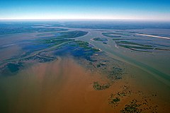
The delta of the Atchafalaya River on the Gulf of Mexico. View is upriver to the northwest.
Autor: SANtosito, Licencja: CC BY-SA 4.0
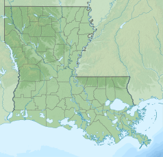
Relief location map of Louisiana, USA
Geographic limits of the map:
- N: 33.2° N
- S: 28.7° N
- W: 94.2° W
- E: 88.6° W
Atchafalaya River, Louisiana
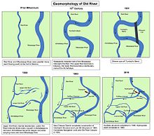
Maps showing the history of the course of the Mississippi river at what is now the Old River Control Structure in Louisiana.
Autor: Uwe Dedering, Licencja: CC BY-SA 3.0
Relief location map of the USA (without Hawaii and Alaska).
EquiDistantConicProjection : Central parallel :
* N: 37.0° N
Central meridian :
* E: 96.0° W
Standard parallels:
* 1: 32.0° N
* 2: 42.0° N
Made with Natural Earth. Free vector and raster map data @ naturalearthdata.com.
Formulas for x and y:
x = 50.0 + 124.03149777329222 * ((1.9694462586094064-({{{2}}}* pi / 180))
      * sin(0.6010514667026994 * ({{{3}}} + 96) * pi / 180))
y = 50.0 + 1.6155950752393982 * 124.03149777329222 * 0.02613325650382181
      - 1.6155950752393982  * 124.03149777329222 *
     (1.3236744353715044  - (1.9694462586094064-({{{2}}}* pi / 180))
      * cos(0.6010514667026994 * ({{{3}}} + 96) * pi / 180))


