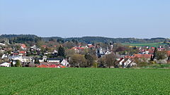
Au in der Hallertau, Au i.d. Hallertau – gmina targowa w Niemczech, w kraju związkowym Bawaria, w rejencji Górna Bawaria, w regionie Monachium, w powiecie Freising. Leży około 20 km na północ od Freising, nad rzeką Abens, w Hallertau, przy drodze B301 i linii kolejowej Rohrbach – Au in der Hallertau.

Kościół pw. św. Wita
(St. Veit)Dzielnice
- Abens
- Dellnhausen
- Dobl
- Grubanger
- Günzenhausen
- Haarbach
- Halsberg
- Harham
- Haslach
- Held
- Hemhausen
| - Herbersdorf
- Hirnkirchen
- Hofen
- Holzhof
- Holzmair (bei Haslach)
- Holzmair (bei Reicherts.)
- Holzschmud
- Kleintonhof
- Königsgütler
- Kranzberg
- Kreiden
| - Kürzling
- Leitersdorf
- Mösbuch
- Mooshof
- Neuhub
- Neuhuber
- Osseltshausen
- Osterwaal
- Piedendorf
- Reichertshausen
- Reith
| - Rohregg
- Rudertshausen
- Schausgrub
- Scheckenhausen
- Seysdorf
- Sillertshausen
- Sindorf
- Trillhof
- Willertshausen
- Wolfersdorf
- Zimmerhans
|
Demografia
Zmiana liczby mieszkańców
| Rok | L. mieszkańców |
|---|
| 1809 | 527 | | 1874 | 801 | | 1885 | 1 010 | | 1907 | 1 214 | | 1910 | 1 293 | | 1919 | 1 367 | | 1925 | 1 403 | | 1933 | 1 388 | | 1939 | 1 481 | | 1946 | 1 475 |
| | Rok | L. mieszkańców |
|---|
| 1950 | 2 022 | | 1955 | 1 976 | | 1960 | 1 936 | | 1965 | 2 013 | | 1971 | 2 159 | | 1972 | 2 424 | | 1975 | 2 428 | | 1976 | 2 588 | | 1978 | 3 718 | | 1980 | 3 826 |
| | Rok | L. mieszkańców |
|---|
| 1982 | 4 234 | | 1984 | 4 305 | | 1989 | 4 508 | | 1994 | 4 912 | | 1999 | 5 250 | | 2000 | 5 209 | | 2003 | 5 467 | | 2004 | 5 461 | | 2005 | 5 552 | | 2008 | 5 571 |
|
Struktura wiekowa
Dane o ludności z dnia 31 grudnia 2008[1]:
| Opis | Ogółem | Kobiety | Mężczyźni |
|---|
| Jednostka | osób | % | osób | % | osób | % |
| Populacja | 5571 | 100 | 2721 | 48,84 | 2850 | 51,16 |
| Wiek przedprodukcyjny (0–17 lat) | 1098 | 19,71 | 511 | 9,17 | 587 | 10,54 |
| Wiek produkcyjny (18–65 lat) | 3618 | 64,94 | 1735 | 31,14 | 1883 | 33,8 |
| Wiek poprodukcyjny (powyżej 65 lat) | 855 | 15,35 | 475 | 8,53 | 380 | 6,82 |
Polityka
Wójtem gminy jest Karl Ecker, rada gminy składa się z 20 osób.
Zobacz też
Przypisy
| Miasta | |
|---|
| Gminy targowe | |
|---|
| Gminy | |
|---|
| Wspólnoty administracyjne | |
|---|


