Auckland (region)
| ||||
| ||||
 | ||||
| Państwo | ||||
| Siedziba | Auckland[1] | |||
| Powierzchnia | 4894 km²[2] | |||
| Populacja (2019) • liczba ludności | 1 642 800[3] | |||
| • gęstość | 336 os./km² | |||
| Plan | ||||
 | ||||
Położenie na mapie | ||||
| Strona internetowa | ||||
| Portal | ||||
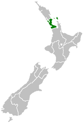
Auckland (maor. Tāmaki-makau-rau) – region administracyjny na nowozelandzkiej Wyspie Północnej.
W 2013 region liczył 1 415 550 mieszkańców, w 2006 – 1 304 961, a w 2001 – 1 160 271[4]. Nie dzieli się na dystrykty[5].
HDI: 0.935 (very high)[6]
Przypisy
- ↑ Wielki Encyklopedyczny Atlas Świata. T. 18. Australia i Oceania. Warszawa: PWN, 2006, s. 38. ISBN 978-83-01-14933-8.
- ↑ Auckland Council, Auckland Council Draft Annual Plan 2011/2012 - Volume 1: Our Region.
- ↑ Subnational population estimates: At 30 June 2019 (provisional) - Statistics New Zealand
- ↑ 2013 Census map – QuickStats about a place (ang.). Statistics New Zealand (Tatauranga Aotearoa. [dostęp 2016-01-23].
- ↑ 2013 Census QuickStats about a place (ang.). Stats NZ. [dostęp 2019-08-06].
- ↑ Sub-national HDI - Area Database - Global Data Lab, hdi.globaldatalab.org.
Media użyte na tej stronie
Flag of New Zealand. Specification: http://www.mch.govt.nz/nzflag/description.html , quoting New Zealand Gazette, 27 June 1902.
Autor: Shaundd, Licencja: CC BY-SA 4.0
Map of the Auckland Region. Map projection Mercator; approximate scale is 1:900,000. Orange and yellow roads are motorways/expressways, orange roads are state highways and brown roads are all other roads.
Auckland area, showing the base of the Northland Peninsula (top left), Auckland city (centre left), the Waikato plains (lower left), the Hauraki Gulf (centre), Coromandel Peninsula (right of centre), and the western Bay of Plenty and city of Tauranga (lower right). "This stunning true-color image provides a rare, cloud-free look at the island nation of New Zealand, including most of its North and South Islands. This scene was acquired by the Moderate Resolution Imaging Spectroradiometer (MODIS), flying aboard NASA’s Terra satellite, on October 23, 2002. New Zealand is situated in the South Pacific Ocean, roughly 2,000 km (1,250 miles) southeast of Australia. Wellington, the capital of New Zealand, is located on the southern tip of the North Island, looking across Cook Strait toward South Island."


