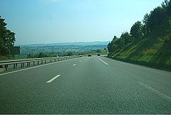
Autostrada A28 (Francja)
| Długość | 307 km | ||||||||||||||||||||||||||||||||||||||||||||||||||||||||||||||||||||||||||||||||||||||||||||||||||||||||||||||||||||||||||||||||||||||||||||||||||||||||||||||||||||||||
| Departamenty | Somme, Sekwana Nadmorska, Eure, Orne, Sarthe, Indre i Loara | ||||||||||||||||||||||||||||||||||||||||||||||||||||||||||||||||||||||||||||||||||||||||||||||||||||||||||||||||||||||||||||||||||||||||||||||||||||||||||||||||||||||||
| Zdjęcie | |||||||||||||||||||||||||||||||||||||||||||||||||||||||||||||||||||||||||||||||||||||||||||||||||||||||||||||||||||||||||||||||||||||||||||||||||||||||||||||||||||||||||
 | |||||||||||||||||||||||||||||||||||||||||||||||||||||||||||||||||||||||||||||||||||||||||||||||||||||||||||||||||||||||||||||||||||||||||||||||||||||||||||||||||||||||||
Autostrada A28 (fr. Autoroute A28) - autostrada we Francji w ciągu tras europejskich E5, E44, E46, E50, E402 oraz E502.
Linki zewnętrzne
Media użyte na tej stronie
BAB-Grenze-dark.svg
Sign no. 392 - Customs, darker version
Sign no. 392 - Customs, darker version
AS-prom rzeka-icon.svg
prom rzeka-icon.
prom rzeka-icon.
AB-Tunnel.svg
(Motorway) tunnel Icon. Drawing similar to Swiss road signs.
(Motorway) tunnel Icon. Drawing similar to Swiss road signs.
AB-Tank.svg
Gas station symbol
Gas station symbol
20 airtransportation inv.svg
AIGA Air Transportation sign (inverted)
AIGA Air Transportation sign (inverted)
OOjs UI icon caret-rtl.svg
Autor: https://phabricator.wikimedia.org/diffusion/GOJU/browse/master/AUTHORS.txt, Licencja: MIT
An icon from the OOjs UI MediaWiki lib.
Autor: https://phabricator.wikimedia.org/diffusion/GOJU/browse/master/AUTHORS.txt, Licencja: MIT
An icon from the OOjs UI MediaWiki lib.
OOjs UI icon caret-ltr.svg
Autor: https://phabricator.wikimedia.org/diffusion/GOJU/browse/master/AUTHORS.txt, Licencja: MIT
An icon from the OOjs UI MediaWiki lib.
Autor: https://phabricator.wikimedia.org/diffusion/GOJU/browse/master/AUTHORS.txt, Licencja: MIT
An icon from the OOjs UI MediaWiki lib.
Autoroute française 16.svg
French motorway A16
French motorway A16
Autoroute française 88.svg
French motorway A88
French motorway A88
Autoroute française 11.svg
French motorway A11
French motorway A11
Gtk-go-forward-ltr.svg
Autor: David Vignoni / ICON KING, Licencja: LGPL
Icon from Nuvola icon theme for KDE 3.x / GNOME 2.
Autor: David Vignoni / ICON KING, Licencja: LGPL
Icon from Nuvola icon theme for KDE 3.x / GNOME 2.
Autoroute française 13.svg
French motorway A13
French motorway A13
France Flag Map.svg
Map showing France with the French flag.
Map showing France with the French flag.
Autoroute française 29.svg
French motorway A29
French motorway A29
Autoroute française 10.svg
French motorway A10
French motorway A10
Autoroute française 28.svg
French motorway A28
French motorway A28
A28 Neufchâtel-en-Bray.jpg
Autor: Autor nie został podany w rozpoznawalny automatycznie sposób. Założono, że to Captain Scarlet (w oparciu o szablon praw autorskich)., Licencja: CC BY 2.5
Autor: Autor nie został podany w rozpoznawalny automatycznie sposób. Założono, że to Captain Scarlet (w oparciu o szablon praw autorskich)., Licencja: CC BY 2.5
- Author: Gregory Deryckère
- Description: motorway A28 near Neufchâtel-en-Bray, France.


