Autostrada D46 (Czechy)
| Długość | 40 km | ||||||||||||||||||||||||||||||||||||||||||||||||||||||||||||||||||||||||||||||||||||||||||||||||||||||||||||||||||||||||||||||||||||||||||||||||||||||||||||||||||||||||
|---|---|---|---|---|---|---|---|---|---|---|---|---|---|---|---|---|---|---|---|---|---|---|---|---|---|---|---|---|---|---|---|---|---|---|---|---|---|---|---|---|---|---|---|---|---|---|---|---|---|---|---|---|---|---|---|---|---|---|---|---|---|---|---|---|---|---|---|---|---|---|---|---|---|---|---|---|---|---|---|---|---|---|---|---|---|---|---|---|---|---|---|---|---|---|---|---|---|---|---|---|---|---|---|---|---|---|---|---|---|---|---|---|---|---|---|---|---|---|---|---|---|---|---|---|---|---|---|---|---|---|---|---|---|---|---|---|---|---|---|---|---|---|---|---|---|---|---|---|---|---|---|---|---|---|---|---|---|---|---|---|---|---|---|---|---|---|---|---|---|
| Kraje | południowomorawski, ołomuniecki | ||||||||||||||||||||||||||||||||||||||||||||||||||||||||||||||||||||||||||||||||||||||||||||||||||||||||||||||||||||||||||||||||||||||||||||||||||||||||||||||||||||||||
| Mapa | |||||||||||||||||||||||||||||||||||||||||||||||||||||||||||||||||||||||||||||||||||||||||||||||||||||||||||||||||||||||||||||||||||||||||||||||||||||||||||||||||||||||||
 | |||||||||||||||||||||||||||||||||||||||||||||||||||||||||||||||||||||||||||||||||||||||||||||||||||||||||||||||||||||||||||||||||||||||||||||||||||||||||||||||||||||||||
| Zdjęcie | |||||||||||||||||||||||||||||||||||||||||||||||||||||||||||||||||||||||||||||||||||||||||||||||||||||||||||||||||||||||||||||||||||||||||||||||||||||||||||||||||||||||||
 Autostrada w Vyškovie | |||||||||||||||||||||||||||||||||||||||||||||||||||||||||||||||||||||||||||||||||||||||||||||||||||||||||||||||||||||||||||||||||||||||||||||||||||||||||||||||||||||||||
| |||||||||||||||||||||||||||||||||||||||||||||||||||||||||||||||||||||||||||||||||||||||||||||||||||||||||||||||||||||||||||||||||||||||||||||||||||||||||||||||||||||||||
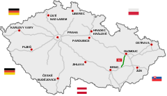
Autostrada D46 (czes. dálnice D46)[1][2] – autostrada w Czechach w ciągu trasy europejskiej E462 łącząca Ołomuniec z autostradą D1.
Budowę tej drogi rozpoczęto w latach 70. XX w. Większość trasy powstała w latach 80., a na początku lat 90. otwarto dla ruchu ostatnie jej odcinki.
Do końca 2015 roku trasa istniała jako droga ekspresowa R46 (rychlostní silnice R46).
Przypisy
- ↑ Z hanácké dálnice bude dálnice skutečná (cz.). pvnovinky.cz, 2015-12-11. [dostęp 2015-12-14].
- ↑ Důvody pro nové pojetí dálniční sítě (cz.). mdcr.cz. [dostęp 2015-12-14]. [zarchiwizowane z tego adresu (2016-03-04)].
Media użyte na tej stronie
Redirect arrow, to be used in redirected articles in Wikipedias written from left to right. Without text.
Sign no. 392 - Customs, darker version
prom rzeka-icon.
(Motorway) tunnel Icon. Drawing similar to Swiss road signs.
Gas station symbol
AIGA Air Transportation sign (inverted)
Autor: David Vignoni / ICON KING, Licencja: LGPL
Icon from Nuvola icon theme for KDE 3.x / GNOME 2.
Autor: David Vignoni / ICON KING, Licencja: LGPL
Icon from Nuvola icon theme for KDE 3.x / GNOME 2.
Autor: https://phabricator.wikimedia.org/diffusion/GOJU/browse/master/AUTHORS.txt, Licencja: MIT
An icon from the OOjs UI MediaWiki lib.
Sign of Czech motorway D46.
Znak D-10: koniec autostrady
Autor: Zirland, Licencja: CC BY-SA 3.0
New design of traffic sign "Highway" (2016)
Sign of motorway 1 in Czech Republic
Sign of planned highway D35 in the Czech Republic
Autor: Lakky, Licencja: CC BY-SA 4.0
Czech highway D46 on its 1st kilometr in direction to Olomouc at interchange Vyškov.


