Autostrada M1 (Wielka Brytania)
| Długość | 193,5 mil / 311,4 km |
|---|---|
| Hrabstwa | Wielki Londyn (region administracyjny), |
| Mapa | |
Nilfanion and Dr Greg. © OpenStreetMap contributors. Contains Ordnance Survey data © Crown copyright and database right 2010., CC BY-SA 4.0 Przebieg autostrady M1 | |
| Zdjęcie | |
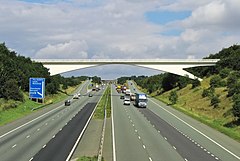
 Autostrada M1 w kierunku Leeds | |
Autostrada M1 – autostrada w Wielkiej Brytanii łącząca Londyn z Leeds w hrabstwie West Yorkshire. Była to pierwsza międzymiastowa autostrada w kraju[1]. Liczy 311,4 km długości.
Większość autostrady M1 została ukończona pomiędzy 1959 a 1968 rokiem. W 1977 roku, na południowym końcu drogi, oddano do użytku krótki odcinek, który połączył M1 z drogą A406. Ostatni odcinek drogi, służący jako przedłużenie autostrady M1 do drogi A1(M), oddano w roku 1999.
Trasy europejskie
Trasa obecnie stanowi fragment jednej trasy europejskiej – E13[a]. Do połowy lat 80. miała wspólny przebieg z dwoma drogami międzynarodowymi – E33 i E106[2].
Współczesne
| Trasa europejska | Przebieg |
|---|---|
| Thurcroft – London |
Historyczne
| Trasa europejska | Przebieg |
|---|---|
| London – Crick[3] | |
| E106 | Northampton – Crick – Leicester – Nottingham – Sheffield – Leeds |
Uwagi
- ↑ Trasy europejskie nie są oznakowane na terenie Wielkiej Brytanii.
Przypisy
- ↑ The Motorway Archive. CIHT. [dostęp 2013-06-22]. (ang.).
- ↑ Hegi Gyula, Domokos György: EUROPE L'EUROPE EUROPA ЕВРОПА Road atlas Atlas Routier Autoatlas АТЛАС автомобильных дорог. Budapeszt: Cartographia Budapest, 1981. ISBN 963-350-412-0.
- ↑ SABRE: E33 (London - Glasgow). Roader's Digest: The SABRE Wiki. [dostęp 2018-10-19]. (ang.).
Media użyte na tej stronie
Sign no. 392 - Customs, darker version
prom rzeka-icon.
(Motorway) tunnel Icon. Drawing similar to Swiss road signs.
Gas station symbol
AIGA Air Transportation sign (inverted)
Symbol used for motorways in the United Kingdom.
Autor: Klaus with K, Licencja: CC BY-SA 3.0
M1 in Yorkshire south of Leeds.
Nilfanion and Dr Greg. © OpenStreetMap contributors. Contains Ordnance Survey data © Crown copyright and database right 2010., CC BY-SA 4.0
The M1 motorway of Great Britain highlighted against the motorways of the United Kingdom in 2016. Equirectangular map projection on WGS 84 datum.
Motorway badge for the M1 motorway


