Autostrada M4 (Wielka Brytania)
| Długość | 189,5 mil / 305 km | |||||||||||||||||||||||||||||||||||||||||||||||||||||||||||||||||||||||||||||||||||||||||||||||||||||||||||||||||||||||||||||||||||||||||||||||||||||||||||||||||||||||||||||||||||||||||||||||||||||||||||||||||||||||||||||||||||||||||||||||||||||||||||||||||||||||||||||||||||||||||||||||||||||||||||||||||||||||||||||||||
|---|---|---|---|---|---|---|---|---|---|---|---|---|---|---|---|---|---|---|---|---|---|---|---|---|---|---|---|---|---|---|---|---|---|---|---|---|---|---|---|---|---|---|---|---|---|---|---|---|---|---|---|---|---|---|---|---|---|---|---|---|---|---|---|---|---|---|---|---|---|---|---|---|---|---|---|---|---|---|---|---|---|---|---|---|---|---|---|---|---|---|---|---|---|---|---|---|---|---|---|---|---|---|---|---|---|---|---|---|---|---|---|---|---|---|---|---|---|---|---|---|---|---|---|---|---|---|---|---|---|---|---|---|---|---|---|---|---|---|---|---|---|---|---|---|---|---|---|---|---|---|---|---|---|---|---|---|---|---|---|---|---|---|---|---|---|---|---|---|---|---|---|---|---|---|---|---|---|---|---|---|---|---|---|---|---|---|---|---|---|---|---|---|---|---|---|---|---|---|---|---|---|---|---|---|---|---|---|---|---|---|---|---|---|---|---|---|---|---|---|---|---|---|---|---|---|---|---|---|---|---|---|---|---|---|---|---|---|---|---|---|---|---|---|---|---|---|---|---|---|---|---|---|---|---|---|---|---|---|---|---|---|---|---|---|---|---|---|---|---|---|---|---|---|---|---|---|---|---|---|---|---|---|---|---|---|---|---|---|---|---|---|---|---|---|---|---|---|---|---|---|---|---|---|---|---|---|---|---|---|---|---|---|---|---|---|---|---|---|---|---|---|---|
| Hrabstwa niemetropolitalne | Greater London, | |||||||||||||||||||||||||||||||||||||||||||||||||||||||||||||||||||||||||||||||||||||||||||||||||||||||||||||||||||||||||||||||||||||||||||||||||||||||||||||||||||||||||||||||||||||||||||||||||||||||||||||||||||||||||||||||||||||||||||||||||||||||||||||||||||||||||||||||||||||||||||||||||||||||||||||||||||||||||||||||||
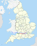
| Mapa | ||||||||||||||||||||||||||||||||||||||||||||||||||||||||||||||||||||||||||||||||||||||||||||||||||||||||||||||||||||||||||||||||||||||||||||||||||||||||||||||||||||||||||||||||||||||||||||||||||||||||||||||||||||||||||||||||||||||||||||||||||||||||||||||||||||||||||||||||||||||||||||||||||||||||||||||||||||||||||||||||||
Nilfanion and Dr Greg. © OpenStreetMap contributors. Contains Ordnance Survey data © Crown copyright and database right 2010., CC BY-SA 4.0 | ||||||||||||||||||||||||||||||||||||||||||||||||||||||||||||||||||||||||||||||||||||||||||||||||||||||||||||||||||||||||||||||||||||||||||||||||||||||||||||||||||||||||||||||||||||||||||||||||||||||||||||||||||||||||||||||||||||||||||||||||||||||||||||||||||||||||||||||||||||||||||||||||||||||||||||||||||||||||||||||||||
| Zdjęcie | ||||||||||||||||||||||||||||||||||||||||||||||||||||||||||||||||||||||||||||||||||||||||||||||||||||||||||||||||||||||||||||||||||||||||||||||||||||||||||||||||||||||||||||||||||||||||||||||||||||||||||||||||||||||||||||||||||||||||||||||||||||||||||||||||||||||||||||||||||||||||||||||||||||||||||||||||||||||||||||||||||
(c) Andrew Smith, CC BY-SA 2.0 Autostrada M4 w okolicach węzła nr 14 | ||||||||||||||||||||||||||||||||||||||||||||||||||||||||||||||||||||||||||||||||||||||||||||||||||||||||||||||||||||||||||||||||||||||||||||||||||||||||||||||||||||||||||||||||||||||||||||||||||||||||||||||||||||||||||||||||||||||||||||||||||||||||||||||||||||||||||||||||||||||||||||||||||||||||||||||||||||||||||||||||||
| ||||||||||||||||||||||||||||||||||||||||||||||||||||||||||||||||||||||||||||||||||||||||||||||||||||||||||||||||||||||||||||||||||||||||||||||||||||||||||||||||||||||||||||||||||||||||||||||||||||||||||||||||||||||||||||||||||||||||||||||||||||||||||||||||||||||||||||||||||||||||||||||||||||||||||||||||||||||||||||||||||
Autostrada M4 (ang. Motorway M4) – autostrada w Wielkiej Brytanii o długości 189,5 mili (305 km), łącząca Londyn ze stolicą Walii – Cardiff oraz Swansea. Stanowi część trasy europejskiej E30 mimo braku oznakowania tego odcinka. Pierwotnie M4 przekraczała rzekę Severn przeprawą Severn Bridge, jednak w latach 90. zbudowano nową przeprawę Second Severn Crossing, natomiast stary odcinek autostrady oznaczono numerem M48.
Jednym z charakterystycznych obiektów znajdujących się w ciągu trasy jest estakada Chiswick Flyover, oddana do użytku we wrześniu 1959 roku[4] pierwotnie jako część drogi A4. W 1964 roku stała się częścią autostrady[4]. Estakada ta uznawana jest za najstarszy odcinek arterii[5].
M4 łączy się z autostradami M25, A308(M), A404(M), A329(M), M32, M5, M48, M49 oraz A48(M). Węzły M4/M25 i M4/M5 są jednymi z nielicznych brytyjskich węzłów autostradowych w formie krzyża maltańskiego[6].
Od 17 grudnia 2018 przejazd mostem nad rzeką Severn jest bezpłatny[7].
Trasy europejskie
Autostrada obecnie stanowi fragment nieoznakowanej w Wielkiej Brytanii trasy europejskiej E30. Do połowy lat 80. miała wspólny przebieg z drogą międzynarodową E105[8].
Współczesne
| Trasa europejska | Przebieg |
|---|---|
| London – Reading – Bristol – Llanelli |
Historyczne
| Trasa europejska | Przebieg |
|---|---|
|
Miasta znajdujące się na trasie autostrady
Przypisy
- ↑ a b c wjazd kier. Swansea, wyjazd kier. Londyn
- ↑ wjazd kier. Londyn, wyjazd kier. Swansea
- ↑ Second Severn Crossing, England and Wales – Halcrow Group. Halcrow.com, 2009-10-29. [zarchiwizowane z tego adresu (2010-03-10)]. (ang.).
- ↑ a b Nick Curtis: The 'sweet little Chiswick Flyover' hits 50. Evening Standard, 2009-10-01. [dostęp 2020-01-03]. (ang.).
- ↑ Chris Marshall: M4. roads.org.uk. [dostęp 2020-01-03]. (ang.).
- ↑ Chris Marshall: Four Level Stack. roads.org.uk. [dostęp 2020-01-03]. (ang.).
- ↑ Peter Shuttleworth: Severn bridges: Final day of at least 800 years of tolls. BBC Wales News, 2018-12-16. [dostęp 2019-01-04]. (ang.).
- ↑ Hegi Gyula, Domokos György: EUROPE L'EUROPE EUROPA ЕВРОПА Road atlas Atlas Routier Autoatlas АТЛАС автомобильных дорог. Budapeszt: Cartographia Budapest, 1981. ISBN 963-350-412-0.
Media użyte na tej stronie
Sign no. 392 - Customs, darker version
prom rzeka-icon.
(Motorway) tunnel Icon. Drawing similar to Swiss road signs.
Gas station symbol
AIGA Air Transportation sign (inverted)
Autor: https://phabricator.wikimedia.org/diffusion/GOJU/browse/master/AUTHORS.txt, Licencja: MIT
An icon from the OOjs UI MediaWiki lib.
Symbol used for motorways in the United Kingdom.
Symbol: Tank
Znak D-10: koniec autostrady
Nilfanion and Dr Greg. © OpenStreetMap contributors. Contains Ordnance Survey data © Crown copyright and database right 2010., CC BY-SA 4.0
The M4 motorway of Great Britain highlighted against the motorways of the United Kingdom in 2016. Equirectangular map projection on WGS 84 datum.
(c) Andrew Smith, CC BY-SA 2.0
The M4, Shefford Woodlands From the bridge just to the east of junction 14.
Motorway badge for the M4 motorway
Contains Ordnance Survey data © Crown copyright and database right, CC BY-SA 3.0
Animated timeline of the development of the M4 motorway, with frames showing the extent open in 1965, 1970, 1975, 1980 and 1996.
Equirectangular map projection on WGS 84 datum, with N/S stretched 160%
Geographic limits:
- West: 4.25W
- East: 0.10W
- North: 52.10N
- South: 50.90N
Autor: Nilfanion, Licencja: CC BY-SA 3.0
Map showing the routes of the M4 motorway and A4 road. The background map shows the European regions of England and Wales. Equirectangular map projection on WGS 84 datum, with N/S stretched 170%


