Autostrada międzystanowa nr 5
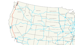
Autostrada międzystanowa nr 5 (ang. Interstate 5, I-5) – amerykańska autostrada międzystanowa o długości 1381,29 mil[1] (2222,97 km) znajdująca się na Zachodnim Wybrzeżu, przebiegająca przez Kalifornię, Oregon i Waszyngton, równolegle do linii brzegowej Oceanu Spokojnego. Rozpoczyna się w San Diego na granicy z Meksykiem, a kończy w Blaine na granicy z Kanadą, około 40 km na południowy wschód od Vancouver. Jest tym samym jedyną autostradą międzystanową, która dotyka zarówno meksykańskiej jak i kanadyjskiej granicy. Budowana była etapami od 1956 do 1979[2].
Główne miasta
- San Diego
- Chula Vista
- Oceanside
- Irvine
- Santa Ana
- Orange
- Anaheim
- Norwalk
- Downey
- Los Angeles
- Glendale
- Burbank
- Santa Clarita
- Stockton
- Sacramento
- Eugene
- Salem
- Portland
- Vancouver
- Tacoma
- Seattle
- Everett
Drogi pomocnicze
- Kalifornia
- autostrada międzystanowa nr 105
- autostrada międzystanowa nr 205
- autostrada międzystanowa nr 405
- autostrada międzystanowa nr 505
- autostrada międzystanowa nr 605
- autostrada międzystanowa nr 805
- Oregon
- autostrada międzystanowa nr 105
- autostrada międzystanowa nr 205
- autostrada międzystanowa nr 405
- Waszyngton
- autostrada międzystanowa nr 205
- autostrada międzystanowa nr 405
- autostrada międzystanowa nr 705
Przypisy
- ↑ Main Routes of the Dwight D. Eisenhower National System Of Interstate and Defense Highways as of October 31, 2002 (ang.). Federal Highway Administration. [dostęp 2012-06-05].
- ↑ Interstate 5 - History (ang.). Interstate Guide. [dostęp 2012-06-05].
Linki zewnętrzne
- Interstate 5 na Interstate Guide (ang.)
- i5highway.com (ang.)
| ||||||||||||||
Media użyte na tej stronie
Sign no. 392 - Customs, darker version
prom rzeka-icon.
(Motorway) tunnel Icon. Drawing similar to Swiss road signs.
Gas station symbol
AIGA Air Transportation sign (inverted)
750 mm × 600 mm (30 in × 24 in) U.S. Highway shield, made to the specifications of the 2004 edition of Standard Highway Signs. (Note that there is a missing "J" label on the left side of the diagram.) Uses the Roadgeek 2005 fonts. (United States law does not permit the copyrighting of typeface designs, and the fonts are meant to be copies of a U.S. Government-produced work anyway.)
600 mm × 600 mm (24 in × 24 in) U.S. Highway shield, made to the specifications of the 2004 edition of Standard Highway Signs. (Note that there is a missing "J" label on the left side of the diagram.) Uses the Roadgeek 2005 fonts. (United States law does not permit the copyrighting of typeface designs, and the fonts are meant to be copies of a U.S. Government-produced work anyway.)
600 mm × 600 mm (24 in × 24 in) U.S. Highway shield, made to the specifications of the 2004 edition of Standard Highway Signs. (Note that there is a missing "J" label on the left side of the diagram.) Uses the Roadgeek 2005 fonts. (United States law does not permit the copyrighting of typeface designs, and the fonts are meant to be copies of a U.S. Government-produced work anyway.)
Uses the Roadgeek 2005 fonts. (United States law does not permit the copyrighting of typeface designs, and the fonts are meant to be copies of a U.S. Government-produced work anyway.) Colors are from [1] (Pantone Red 187 and Blue 294), converted to RGB by [2]. The outside border has a width of 1 (1 mm) and a color of black so it shows up; in reality, signs have no outside border.
Autor: Philkon (Phil Konstantin), Licencja: CC BY-SA 3.0
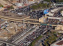
Aerial view of the U.S. San Ysidro Port of Entry (left), and Méxican El Chaparral Point of Entry (right).
- The border crossing between San Diego, California and Tijuana, Baja California state.
- The NRHP-listed U.S. Inspection Station/U.S. Custom House is at top-left, in San Diego, California.
600 mm × 600 mm (24 in × 24 in) U.S. Highway shield, made to the specifications of the 2004 edition of Standard Highway Signs. (Note that there is a missing "J" label on the left side of the diagram.) Uses the Roadgeek 2005 fonts. (United States law does not permit the copyrighting of typeface designs, and the fonts are meant to be copies of a U.S. Government-produced work anyway.)
600 mm × 600 mm (24 in × 24 in) U.S. Highway shield, made to the specifications of the 2004 edition of Standard Highway Signs. (Note that there is a missing "J" label on the left side of the diagram.) Uses the Roadgeek 2005 fonts. (United States law does not permit the copyrighting of typeface designs, and the fonts are meant to be copies of a U.S. Government-produced work anyway.)
Autor: Downtowngal, Licencja: CC BY-SA 3.0
Interstate 5 northbound just before the split with Interstate 10 east. Location is east of downtown Los Angeles.
600 mm × 600 mm (24 in × 24 in) U.S. Highway shield, made to the specifications of the 2004 edition of Standard Highway Signs. (Note that there is a missing "J" label on the left side of the diagram.) Uses the Roadgeek 2005 fonts. (United States law does not permit the copyrighting of typeface designs, and the fonts are meant to be copies of a U.S. Government-produced work anyway.)
750 mm × 600 mm (30 in × 24 in) U.S. Highway shield, made to the specifications of the 2004 edition of Standard Highway Signs. (Note that there is a missing "J" label on the left side of the diagram.) Uses the Roadgeek 2005 fonts. (United States law does not permit the copyrighting of typeface designs, and the fonts are meant to be copies of a U.S. Government-produced work anyway.)
600 mm × 600 mm (24 in × 24 in) U.S. Highway shield, made to the specifications of the 2004 edition of Standard Highway Signs. (Note that there is a missing "J" label on the left side of the diagram.) Uses the Roadgeek 2005 fonts. (United States law does not permit the copyrighting of typeface designs, and the fonts are meant to be copies of a U.S. Government-produced work anyway.)
600 mm × 600 mm (24 in × 24 in) U.S. Highway shield, made to the specifications of the 2004 edition of Standard Highway Signs. (Note that there is a missing "J" label on the left side of the diagram.) Uses the Roadgeek 2005 fonts. (United States law does not permit the copyrighting of typeface designs, and the fonts are meant to be copies of a U.S. Government-produced work anyway.)
600 mm by 600 mm (24 in by 24 in) Interstate shield, made to the specifications of the 2004 edition of Standard Highway Signs (sign M1-1). Uses the Roadgeek 2005 fonts. (United States law does not permit the copyrighting of typeface designs, and the fonts are meant to be copies of a U.S. Government-produced work anyway.) Colors are from [1] (Pantone Red 187 and Blue 294), converted to RGB by [2]. The outside border has a width of 1 (1 mm) and a color of black so it shows up; in reality, signs have no outside border.
