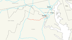
Autostrada międzystanowa nr 66
| Długość | 76,28 mili / 122,05[1] km |
| Stany | Wirginia (74,8 mili), Dystrykt Kolumbii (1,48 mili) |
| Mapa | |
 | |
Interstate 66 − autostrada międzystanowa w USA. Prowadzi z Front Royal do Waszyngtonu. Przebiega przez Wirginię i Dystrykt Kolumbii. Jej długość to 76,28 mili (122,05 km)[1].
Przebieg
 Wirginia
 Dystrykt Kolumbii
Przypisy
- ↑ a b Interstate-Guide: Interstate 66 (ang.)
| ||||||||||||||
Media użyte na tej stronie
Sign no. 392 - Customs, darker version
prom rzeka-icon.
(Motorway) tunnel Icon. Drawing similar to Swiss road signs.
Gas station symbol
AIGA Air Transportation sign (inverted)
Uses the Roadgeek 2005 fonts. (United States law does not permit the copyrighting of typeface designs, and the fonts are meant to be copies of a U.S. Government-produced work anyway.) Colors are from [1] (Pantone Red 187 and Blue 294), converted to RGB by [2]. The outside border has a width of 1 (1 mm) and a color of black so it shows up; in reality, signs have no outside border.


