Autostrada międzystanowa nr 68
| Długość | 116 mile / 187 km | ||||||||||||||||||||||||||||||||||||||||||||||||||||||||||||||||||||||||||||||
| Stany | Maryland, Wirginia Zachodnia | ||||||||||||||||||||||||||||||||||||||||||||||||||||||||||||||||||||||||||||||
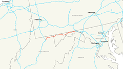
| Mapa | |||||||||||||||||||||||||||||||||||||||||||||||||||||||||||||||||||||||||||||||
 Przebieg trasy I-68 | |||||||||||||||||||||||||||||||||||||||||||||||||||||||||||||||||||||||||||||||
| Zdjęcie | |||||||||||||||||||||||||||||||||||||||||||||||||||||||||||||||||||||||||||||||
 National Freeway | |||||||||||||||||||||||||||||||||||||||||||||||||||||||||||||||||||||||||||||||
| |||||||||||||||||||||||||||||||||||||||||||||||||||||||||||||||||||||||||||||||
Interstate 68 – autostrada międzystanowa w Stanach Zjednoczonych. Przebiega ze wschodu na zachód, z miejscowości Hancock w stanie Maryland do Morgantown w stanie Wirginia Zachodnia. Jej długość wynosi 116 mil (187 km). Budowę autostrady rozpoczęto w połowie lat 60. XX wieku, a do użytku oddano oficjalnie 2 sierpnia 1991 roku.
W stanie Maryland Interstate 68 określa się również jako National Freeway.
Linki zewnętrzne
- Economic Development History of Interstate 68 in Maryland U.S. Department of Transportation, Federal Highway Administration (ang.)
- National Freeway (I-68) Roads to the future] (ang.)
| ||||||||||||||
Media użyte na tej stronie
Sign no. 392 - Customs, darker version
prom rzeka-icon.
(Motorway) tunnel Icon. Drawing similar to Swiss road signs.
Gas station symbol
AIGA Air Transportation sign (inverted)
Uses the Roadgeek 2005 fonts. (United States law does not permit the copyrighting of typeface designs, and the fonts are meant to be copies of a U.S. Government-produced work anyway.) Colors are from [1] (Pantone Red 187 and Blue 294), converted to RGB by [2]. The outside border has a width of 1 (1 mm) and a color of black so it shows up; in reality, signs have no outside border.
Uses the Roadgeek 2005 fonts. (United States law does not permit the copyrighting of typeface designs, and the fonts are meant to be copies of a U.S. Government-produced work anyway.) Colors are from [1] (Pantone Red 187 and Blue 294), converted to RGB by [2]. The outside border has a width of 1 (1 mm) and a color of black so it shows up; in reality, signs have no outside border.
Interstate 68 Driving East, 18 Miles from Cumberland.


