Autostrady w Irlandii
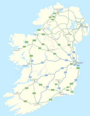
Autostrady w Irlandii – sieć dróg szybkiego ruchu na terenie Republiki Irlandii. Drogi te rozchodzą się głównie promieniście od stolicy kraju, Dublina. Oznakowane są numerem drogi krajowej z przedrostkiem M od irlandzkiego słowa mótarbhealach (w liczbie mnogiej mótarbhealaí) oznaczającego autostradę.
Przepisy na autostradzie
Autostrady w Irlandii posiadają szereg przepisów, które zabraniają przemieszczenia się na nich określonemu rodzaju ruchu[1]. Są to m.in.:
- pojazdy do nauki jazdy
- pojazdy nie osiągające prędkości 50 km/h
- piesi
- rowery
- pojazdy z silnikami poniżej 50 cm³ pojemności
- pojazdy bez opon pneumatycznych
- zwierzęta
Spis autostrad
Tabela przedstawia zestawienie istniejących na 2021 rok autostrad[2]
| Numer | Mapa | Odcinek | Długość |
|---|---|---|---|
 | Dublin – Dundalk | 87 km | |
 | Dublin – Ashbourne | 13 km | |
 | Dublin – Kells | 53 km | |
 | Dublin – Mullingar | 62 km | |
| (Dublin) Kinnegad – Galway | 148 km | ||
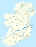
| (Dublin) Naas – Limerick | 166,5 km | ||
| (Dublin) Abbeyleix – Cork | 147 km | ||
| (Dublin) Newbrigde – Waterford | 119 km | ||
| Dublin – Wexford | 90 km | ||
| Galway – Tuam | 25,5 km | ||
| (Limerick) Shannon – Galway | 70,8 km | ||
| Limerick – N20/N21 | 8 km | ||
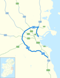
| Obwodnica Dublina | 45,5 km |
Przypisy
- ↑ Rules for driving on Irish motorways [zarchiwizowane z adresu 2008-12-21].
- ↑ Our National Road Network -, www.tii.ie [dostęp 2021-02-05].
Media użyte na tej stronie
Symbol used for motorways in the United Kingdom.
"M18 Motorway Shield"
This is a symbol for the M7 Irish Motorway (Dublin to Limerick, under construction as of June 2009)
Norwegian road sign 502.0.
M50 Ireland Symbol
Autor: Sswonk (talk), Licencja: CC BY-SA 3.0
Map of M2 motorway (Ireland) and Dublin area roads with M2 blue bolded, Nxx routes in green and Mxx routes in blue
Sweden road sign: Information signs - Motorväg / Autostrada
M1 Motorway Symbol Ireland
(c) Sswonk z angielskiej Wikipedii, CC BY-SA 3.0
Map of M50 motorway (Ireland) and Dublin area roads with M50 blue bolded, Nxx routes in green and Mxx routes in blue
This is a symbol for the M3 Irish Motorway (under construction as of June 2009)
This is a symbol for the M9 Irish Motorway (Naas to Waterford, under construction as of June 2009)
"M2 marker"
(c) Sswonk z angielskiej Wikipedii, CC BY-SA 3.0
Map of M20 motorway (Ireland) with M20 blue bolded, Nxx routes in green and Mxx routes in blue
(c) Sswonk z angielskiej Wikipedii, CC BY-SA 3.0
Map of M6 motorway (Ireland) with M6 blue bolded, Nxx routes in green and Mxx routes in blue
Autor: Sswonk (talk), Licencja: CC BY-SA 3.0
Map of M1 motorway (Ireland) with M1 blue bolded, Nxx routes in green and Mxx routes in blue
(c) Sswonk z angielskiej Wikipedii, CC BY-SA 3.0
Map of M7 motorway (Ireland) with M7 blue bolded, Nxx routes in green and Mxx routes in blue
Autor: Sswonk (talk), Licencja: CC BY-SA 3.0
Map of M4 motorway (Ireland) with M4 blue bolded, Nxx routes in green and Mxx routes in blue
(c) Sswonk z angielskiej Wikipedii, CC BY-SA 3.0
Map of M9 motorway (Ireland) with M9 blue bolded, Nxx routes in green and Mxx routes in blue
Autor: Sswonk (talk), Licencja: CC BY-SA 3.0
Map of M3 motorway (Ireland) with M3 blue bolded, Nxx routes in green and Mxx routes in blue
"M11 Motorway Shield Ireland"
This is a symbol for the M8 Irish Motorway (Cork to Portlaoise)
M20 Route Confitmation Sign Ireland
This is a symbol for the M6 Irish Motorway (Kinnegad to Galway)
This is a symbol for the M4 Irish Motorway (from Kinnegad to Dublin)
(c) Sswonk z angielskiej Wikipedii, CC BY-SA 3.0
Map of M8 motorway (Ireland) with M8 blue bolded, Nxx routes in green and Mxx routes in blue
Autor: Ww2censor based on work by Sswonk, Licencja: CC BY-SA 3.0
Updated map of national roads and motorways in Ireland, with Nxx routes in green and Mxx routes in blue as of 2018
M17 Route Marker Ireland


