Aviemore
 (c) John G Burns, CC BY-SA 2.0 | |
| Państwo | |
|---|---|
| Kraj | |
| Hrabstwo | Highland |
| Populacja (2006) • liczba ludności | 2 440 |
Położenie na mapie Highland  Contains Ordnance Survey data © Crown copyright and database right, CC BY-SA 3.0 | |
Położenie na mapie Wielkiej Brytanii  (c) Karte: NordNordWest, Lizenz: Creative Commons by-sa-3.0 de | |
Położenie na mapie Szkocji | |
| Portal | |
Aviemore (gael. An Aghaidh Mhòr) – miejscowość w Szkocji. Znajduje się w Highlands w okolicach drogi A9. Znajduje się tu jeden z popularniejszych ośrodków sportów zimowych.
Większe imprezy
- w dniach 22-27 lutego 1976 roku odbyły się tu Mistrzostwa Świata Juniorów w Curlingu.
- w dniach 24-26 sierpnia 1976 roku odbyły się tu Mistrzostwa Świata w Biegu na Orientację.
- w 1978 roku odbyły się tu Mistrzostwa Europy w Curlingu
Galeria
 (c) Anne Burgess, CC BY-SA 2.0
 (c) Nigel Brown, CC BY-SA 2.0
 (c) Richard Webb, CC BY-SA 2.0
Linki zewnętrzne
Media użyte na tej stronie
United Kingdom adm location map.svg
(c) Karte: NordNordWest, Lizenz: Creative Commons by-sa-3.0 de
Location map of the United Kingdom
(c) Karte: NordNordWest, Lizenz: Creative Commons by-sa-3.0 de
Location map of the United Kingdom


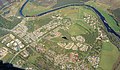
Aviemore - geograph.org.uk - 12871.jpg
(c) Anne Burgess, CC BY-SA 2.0
Aviemore. The village of Aviemore has expanded enormously in recent decades as more and more tourist accommodation has been built.
(c) Anne Burgess, CC BY-SA 2.0
Aviemore. The village of Aviemore has expanded enormously in recent decades as more and more tourist accommodation has been built.
Highland UK location map.svg
Contains Ordnance Survey data © Crown copyright and database right, CC BY-SA 3.0
Contains Ordnance Survey data © Crown copyright and database right, CC BY-SA 3.0
Blank map of Highland, UK with the following information shown:
- Administrative borders
- Coastline, lakes and rivers
- Roads and railways
- Urban areas
Equirectangular map projection on WGS 84 datum, with N/S stretched 180%
Geographic limits:
- West: 6.9W
- East: 2.9W
- North: 58.8N
- South: 56.4N

The Old Bridge Inn - geograph.org.uk - 326455.jpg
(c) Richard Webb, CC BY-SA 2.0
The Old Bridge Inn This is the old road through Aviemore. It is on the opposite side of the railway to the current road.
(c) Richard Webb, CC BY-SA 2.0
The Old Bridge Inn This is the old road through Aviemore. It is on the opposite side of the railway to the current road.

Scotland location map.svg
(c) Eric Gaba, NordNordWest, CC BY-SA 3.0
Location map of Scotland, United Kingdom
(c) Eric Gaba, NordNordWest, CC BY-SA 3.0
Location map of Scotland, United Kingdom