Axamer Lizum
 | |
| Państwo | |
|---|---|
| Kraj związkowy | |
| Powiat | |
| Gmina | |
| Wysokość | 1564 m n.p.m. |
| Populacja • liczba ludności |
|
| Kod pocztowy | 6094 |
| Strona internetowa | |
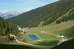
Axamer Lizum – wieś rozproszona w Austrii, w kraju związkowym Tyrol. Pod względem administracyjnym jest częścią gminy Axams, w powiecie Innsbruck-Land. Leży w paśmie Stubaier Alpen, znajduje się tu ośrodek sportów zimowych. W 1964 roku rozegrano tu większość konkurencji narciarstwa alpejskiego podczas IX Zimowych Igrzysk Olimpijskich[1]. Axamer Lizum gościło także olimpijczyków podczas rozgrywanych dwanaście lat później XII Igrzysk Olimpijskich[2].
Przypisy
- ↑ Sports Reference.com: Alpine Skiing at the 1964 Innsbruck Winter Games. sports-reference.com. [zarchiwizowane z tego adresu (2009-04-01)]. (ang.).
- ↑ Sports Reference.com: Alpine Skiing at the 1976 Innsbruck Winter Games. sports-reference.com. [zarchiwizowane z tego adresu (2009-10-16)]. (ang.).
Bibliografia
- Oficjalna strona. axamer-lizum.at. [zarchiwizowane z tego adresu (2017-11-07)]. (niem.).
Media użyte na tej stronie
Autor: Rosso Robot, Licencja: CC BY-SA 3.0
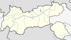
Location map of The Tyrol
Equirectangular projection. Geographic limits of the map:
- N: 47.75317° N
- S: 46.64119° N
- W: 10.08236° E
- E: 12.98961° E
Autor: Lencer, Licencja: CC BY-SA 3.0
Location map of Austria
Equirectangular projection, N/S stretching 150 %. Geographic limits of the map:
- N: 49.2° N
- S: 46.3° N
- W: 9.4° E
- E: 17.2° E
The Axamer Lizum from south, in the background the Karwendel with Großer Solstein (left) and Kleiner Solstein (right), Tyrol, Austria


