Azay-le-Rideau
| miejscowość i gmina | |||
 | |||
| |||
| Państwo | |||
|---|---|---|---|
| Region | |||
| Departament | |||
| Okręg | |||
| Kod INSEE | 37014 | ||
| Powierzchnia | 27,26 km² | ||
| Populacja (1990) • liczba ludności |
| ||
| • gęstość | 112 os./km² | ||
| Kod pocztowy | 37190 | ||
| Portal | |||
Azay-le-Rideau – miejscowość i gmina we Francji, w Regionie Centralnym, w departamencie Indre i Loara.
Według danych na rok 1990 gminę zamieszkiwały 3053 osoby, a gęstość zaludnienia wynosiła 112 osób/km² (wśród 1842 gmin Regionu Centralnego Azay-le-Rideau plasuje się na 111. miejscu pod względem liczby ludności, natomiast pod względem powierzchni na miejscu 413.).
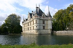
W Azay-le-Rideau znajduje się zamek wybudowany w okresie 1518-1527 i jest to jeden z pierwszych zamków francuskiego renesansu. Zbudowany na wyspie na rzece Indre jego fundamenty wyrastają wprost z rzeki.
Miasta partnerskie
Zobacz też
Bibliografia
- Francuski urząd statystyczny. (fr.).
Media użyte na tej stronie
Autor: Flappiefh, Licencja: CC BY-SA 4.0
Blank administrative map of the department of Indre-et-Loire, France, for geo-location purpose.
Autor: Superbenjamin, Licencja: CC BY-SA 4.0
Blank administrative map of France for geo-location purpose, with regions and departements distinguished. Approximate scale : 1:3,000,000
Autor: Flappiefh, Licencja: CC BY-SA 4.0
Carte administrative vierge de la région Centre-Val de Loire, France, destinée à la géolocalisation.
Flag of Portugal, created by Columbano Bordalo Pinheiro (1857-1929), officially adopted by Portuguese government in June 30th 1911 (in use since about November 1910). Color shades matching the RGB values officially reccomended here. (PMS values should be used for direct ink or textile; CMYK for 4-color offset printing on paper; this is an image for screen display, RGB should be used.)
Autor: Gerd Eichmann, Licencja: CC BY-SA 4.0
Schloss in Azay-le-Rideau
Azay-le-Rideau, vu du château, France


