Bad Zwischenahn
| gmina | |||||
 | |||||
| Państwo | |||||
|---|---|---|---|---|---|
| Kraj związkowy | |||||
| Powiat | Ammerland | ||||
| Powierzchnia | 130,00 km² | ||||
| Wysokość | 7 m n.p.m. | ||||
| Populacja (31.12.2008) • liczba ludności | 27 350 | ||||
| • gęstość | 210 os./km² | ||||
| Numer kierunkowy | 04403 | ||||
| Kod pocztowy | 26160 | ||||
| Tablice rejestracyjne | WST | ||||
Adres urzędu: Am Brink 926160 Bad Zwischenahn | |||||
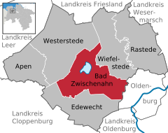
Położenie na mapie powiatu | |||||
| 53°11′N 8°01′E/53,183333 8,016667 | |||||
| Strona internetowa | |||||
| Portal | |||||
Bad Zwischenahn (dolnoniem. Twüschenahn) – uzdrowiskowa gmina samodzielna (niem. Einheitsgemeinde) w Niemczech w kraju związkowym Dolna Saksonia, w powiecie Ammerland. W 2008 r. gmina liczyła 27 350 mieszkańców.
W Bad Zwischenahn znajduje się stacja kolejowa.
Współpraca
 Izegem, Belgia
 Centerville, Stany Zjednoczone
 Gołuchów, Polska
Media użyte na tej stronie
The flag of Navassa Island is simply the United States flag. It does not have a "local" flag or "unofficial" flag; it is an uninhabited island. The version with a profile view was based on Flags of the World and as a fictional design has no status warranting a place on any Wiki. It was made up by a random person with no connection to the island, it has never flown on the island, and it has never received any sort of recognition or validation by any authority. The person quoted on that page has no authority to bestow a flag, "unofficial" or otherwise, on the island.
|
|
|
|
|
|
|
|
Autor: De-okin (talk) 11:49, 12 April 2009 (UTC), Licencja: CC-BY-SA-3.0
aerial-view of Bad Zwischenahn, Lower Saxony, Germany


