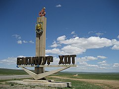
Bagnuur
| ||||
| ||||
 | ||||
| Państwo | ||||
| Miasto | Ułan Bator | |||
| Data założenia | 1992 | |||
| Powierzchnia | 620,2 km² | |||
| Populacja (2013) • liczba ludności | 27 440 | |||
| • gęstość | 41,9 os./km² | |||
| Liczba osiedli | 5 | |||
Położenie na mapie Ułan Bator | ||||
| 47°47′02″N 108°22′20″E/47,783889 108,372222 | ||||
| Strona internetowa | ||||
Bagnuur (mong. Багануур) – dzielnica Ułan Bator, stolicy Mongolii.
Dzielnica została utworzona w 1992 roku, na terenach dawnej radzieckiej bazy wojskowej. Stanowi eksklawę położoną 130 km na wschód od terytorium Ułan Bator, na granicy ajmaków centralnego i chentejskiego[1][2]. Obejmuje terytorium 620,2 km² i składa się z 5 osiedli. W 2013 roku liczyła 27 440 mieszkańców[3].
Dzielnica o charakterze wybitnie przemysłowym, na jej terenie znajduje się jedna z największych w Mongolii kopalni węgla[1].
Przypisy
- ↑ a b Alan J.K. Sanders: Historical Dictionary of Mongolia. Lanham: Scarecrow Press, 2010, s. 81.
- ↑ Districts of Ulaanbaatar (ang.). ulaanbaatar.mn. [dostęp 2015-01-09].
- ↑ Ulaanbaatar (Ulan-Bator) General Information (ang.). infomongolia.com. [dostęp 2015-01-09].
Media użyte na tej stronie
Map of Ulaanbaatar, created by Bogomolov.PL; using various mapping resources
Autor: Steve Burt, Licencja: CC BY-SA 2.0
A sign marking the entrance to the city of Baganuur in Mongolia. Baganuur is formally a Düüreg (district) of the capital Ulaanbaatar. Geographically it is a seperate city located as an exclave on the border between the Töv and Khentii Aimags.


