Bahyr Dar
| Państwo | |
|---|---|
| Kyllyl | |
| Wysokość | 1840 m n.p.m. |
| Populacja (2005) • liczba ludności |
|
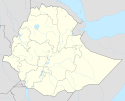
Położenie na mapie Etiopii (c) Karte: NordNordWest, Lizenz: Creative Commons by-sa-3.0 de | |
Bahyr Dar (Bahir Dar) – miasto w północno-zachodniej Etiopii; położone nad jeziorem Tana; stolica regionu Amhara; 186 tys. mieszkańców (2006). Ośrodek handlowy regionu rolniczego, przemysł włókienniczy, olejarski, ośrodek turystyczny; w pobliżu na Nilu Błękitnym elektrownia wodna i wodospady Tys Ysat.
Miasta partnerskie
Media użyte na tej stronie
The flag of Navassa Island is simply the United States flag. It does not have a "local" flag or "unofficial" flag; it is an uninhabited island. The version with a profile view was based on Flags of the World and as a fictional design has no status warranting a place on any Wiki. It was made up by a random person with no connection to the island, it has never flown on the island, and it has never received any sort of recognition or validation by any authority. The person quoted on that page has no authority to bestow a flag, "unofficial" or otherwise, on the island.
Flag of the Amhara Region
Flag of Ethiopia
(c) Karte: NordNordWest, Lizenz: Creative Commons by-sa-3.0 de
Location map of Ethiopia


