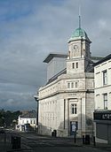
Ballymena
(c) Lisa Jarvis, CC BY-SA 2.0 Ratusz w Ballymenie | |
| Państwo | |
|---|---|
| Prowincja | |
| Hrabstwo | |
| Dystrykt | Mid and East Antrim |
| Populacja (2011) • liczba ludności |
|
| Nr kierunkowy | 028 |
Położenie na mapie Wielkiej Brytanii (c) Karte: NordNordWest, Lizenz: Creative Commons by-sa-3.0 de | |
| Strona internetowa | |
| Portal | |
Ballymena (wym. [ˌbæliˈmiːnə]; irl. An Baile Meánach [ən̪ˠ ˈbˠalʲə ˈmˠaːn̪ˠəx]) – miasto w Irlandii Północnej (Wielka Brytania), w hrabstwie Antrim, w dystrykcie Mid and East Antrim, położone nad rzeką Main, około 40 km na północny zachód od Belfastu[2]. W 2011 roku liczyło 29 551 mieszkańców[1].
W mieście działa Polska Szkoła Sobotnia[3].
Demografia
W 2011 roku 5,7% mieszkańców potrafiło posługiwać się, w różnym stopniu zaawansowania, językiem irlandzkim, a 17,7% – ulsterskim dialektem języka scots(ang.). Dla 6,3% mieszkańców język angielski nie był językiem ojczystym. 26,7% osób wyznawało lub zostało wychowanych w wierze katolickiej, a 65,8% – protenstanckiej bądź w innym odłamie chrześcijaństwa[1].
Gospodarka
W mieście znajduje się siedziba firmy motoryzacyjnej Wrightbus, zajmującej się produkcją autobusów[4]. W mieście funkcjonuje również jej fabryka, w której wyprodukowano m.in. autobusy New Routemaster dla Londynu[5].
Sport
- Ballymena United F.C. – klub męskiej piłki nożnej
- Ballymena United Allstars F.C. – klub kobiecej piłki nożnej
Współpraca
Przypisy
- ↑ a b c Census 2011. Usual Resident Population: KS101NI (Settlement 2015). Northern Ireland Statistics and Research Agency. [dostęp 2020-04-19]. (ang.).
- ↑ Ballymena, [w:] Encyclopædia Britannica [online] [dostęp 2021-12-29] (ang.).
- ↑ Baza organizacji i instytucji polskich i polonijnych za granicą. Główny Urząd Statystyczny. [dostęp 2018-08-12].
- ↑ Wrightbus to boost Ballymena workforce by 300, „BBC News”, 17 sierpnia 2021 [dostęp 2021-12-28] (ang.).
- ↑ Transport for London | Every Journey Matters, Mayor drives first New Bus for London off production line, Transport for London [dostęp 2021-12-28] (ang.).
Media użyte na tej stronie
Autor: NordNordWest, Licencja: CC BY-SA 3.0
Location map of Northern Ireland
(c) Karte: NordNordWest, Lizenz: Creative Commons by-sa-3.0 de
Location map of the United Kingdom
Ulster Banner is a heraldic banner taken from the former coat of arms of Northern Ireland. It was used by the Northern Ireland government in 1953-1973 with Edwardian crown since coronation of Queen Elizabeth II, based earlier design with Tudor Crown from 1924. Otherwise known as the Ulster Flag, Red Hand of Ulster Flag, Red Hand Flag.
Ulster Banner is a heraldic banner taken from the former coat of arms of Northern Ireland. It was used by the Northern Ireland government in 1953-1973 with Edwardian crown since coronation of Queen Elizabeth II, based earlier design with Tudor Crown from 1924. Otherwise known as the Ulster Flag, Red Hand of Ulster Flag, Red Hand Flag.
Flag of Gibraltar
The flag of Navassa Island is simply the United States flag. It does not have a "local" flag or "unofficial" flag; it is an uninhabited island. The version with a profile view was based on Flags of the World and as a fictional design has no status warranting a place on any Wiki. It was made up by a random person with no connection to the island, it has never flown on the island, and it has never received any sort of recognition or validation by any authority. The person quoted on that page has no authority to bestow a flag, "unofficial" or otherwise, on the island.


