Balmoral
 | |
| Państwo | |
|---|---|
| Kraj | |
| Miejscowość | Easter Balmoral (najbliższa wieś) |
| Typ budynku | zamek, rezydencja królewska |
| Ważniejsze przebudowy | |
| Właściciel | rodzina królewska |
Położenie na mapie Aberdeenshire Contains Ordnance Survey data © Crown copyright and database right, CC BY-SA 3.0 | |
Położenie na mapie Wielkiej Brytanii (c) Karte: NordNordWest, Lizenz: Creative Commons by-sa-3.0 de | |
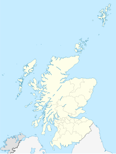
Położenie na mapie Szkocji | |
| Strona internetowa | |

Balmoral – posiadłość w północno-wschodniej Szkocji, w hrabstwie Aberdeenshire, położona nad rzeką Dee, w dolinie Royal Deeside, około 80 km na zachód od Aberdeen. Zajmuje powierzchnię 20 000 hektarów. Jest jedną z dwóch – obok Sandringham House – rezydencji królewskich nienależących do dóbr, którymi brytyjscy monarchowie dysponują z racji pełnionego urzędu (tzw. Crown Estate), lecz pozostających własnością prywatną rodziny panującej.
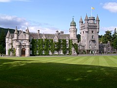
Mieści się tam zamek (wzmiankowany po raz pierwszy w 1484[1]) przebudowany i rozbudowany w latach 1853–1856 w stylu Scottish Baronial dla królowej Wiktorii i jej małżonka – księcia Alberta[2]. Zamek charakteryzuje się wieżą na planie kwadratu z okrągłą wieżyczką w jednym z rogów i trzema bartyzanami – w pozostałych.
Balmoral jest ulubioną letnią rezydencją brytyjskiej rodziny królewskiej.
8 września 2022 roku w rezydencji zmarła królowa Elżbieta II[3].
Przypisy
- ↑ The British Isles, British Tourist Association, Colour Library Books Ltd, Guildford Surrey, 1987, ISBN 0-86283-556-9.
- ↑ Neil Wilson: Lonely Planet Scotland. Wyd. 5. Londyn: Lonely Planet, 2008, s. 255. ISBN 978-1-7410-459-01.
- ↑ Queen Elizabeth II, Britain’s longest-reigning monarch, dies aged 96, the Guardian, 8 września 2022 [dostęp 2022-09-08] (ang.).
Linki zewnętrzne
Media użyte na tej stronie
(c) Karte: NordNordWest, Lizenz: Creative Commons by-sa-3.0 de
Location map of the United Kingdom
(c) Eric Gaba, NordNordWest, CC BY-SA 3.0
Location map of Scotland, United Kingdom
Blue Shield - the Distinctive emblem for the Protection of Cultural Property. The distinctive emblem is a protective symbol used during armed conflicts. Its use is restricted under international law.
Autor: Praca własna, Licencja: CC-BY-SA-3.0
Queen Elizabeth II's personal flag (1960)
Contains Ordnance Survey data © Crown copyright and database right, CC BY-SA 3.0
Blank map of Aberdeenshire, UK with the following information shown:
- Administrative borders
- Coastline, lakes and rivers
- Roads and railways
- Urban areas
Equirectangular map projection on WGS 84 datum, with N/S stretched 180%
Geographic limits:
- West: 3.85W
- East: 1.70W
- North: 57.75N
- South: 56.70N
This painting by Victoria of the new Balmoral, designed by Albert to resemble his native German castles,
was made in 1852 while it was being built.
Sketchbook Illustration: 4 October 1852 “Balmoral Castle from the Approach (Abergeldie Side)”. Watercolour, by Queen Victoria. Inventory number: K.55 f.66 (18.5 x 17.8 cm)
A watercolour showing Balmoral Castle from the East. The approach to the castle is shown in the foreground, lined with trees either side. The partial view of the castle is shown behind the trees with mountains shown in the background. Inscribed below pasted down sheet: Balmoral Castle from the Approach (Abergeldie side) Inscribed lower right: VR del: Oct: 4 - 1852. In her journal entry of 4 October 1852, Queen Victoria describes how she "had been out & near the house, ever since 10, remaining out sketching till ½ p. 12" before going deer stalking with her family.Autor: Stuart Yeates z Oxford, UK, Licencja: CC BY-SA 2.0
Balmoral Castle. The Royal Standard of Scotland flies over it.


