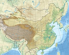
Banggong Co
| ||
 | ||
| Położenie | ||
| Państwo | ||
| Wysokość lustra | 4241 m n.p.m. | |
| Morfometria | ||
| Powierzchnia | 604 km² | |
| Głębokość • maksymalna | 41,3 m | |
| Hydrologia | ||
| Rodzaj jeziora | endoreiczne | |
Banggong Co (tyb. སྤང་གོང་མཚོ། མཚོ་མོ་ངང་ལྷ་རིང་པོ, Wylie: spang gong mtsho; chiń. upr. 班公错; pinyin Bāngōng Cuò; hindi पांगोंग त्सो, Pangong Tso) – jezioro endoreiczne w Himalajach, rozdzielone granicą między Chiny i Indie. Jest zasolone w części zachodniej. Leży na wysokości 4241 m n.p.m. i zajmuje powierzchnię 604 km². Najgłębszy punkt znajduje się we wschodniej części zbiornika i osiąga 41,3 m[1].
Przypisy
- ↑ 王苏民: 中国湖泊志. 北京: 科学出版社, 1998, s. 401. ISBN 7-03-006706-1.
Media użyte na tej stronie
Autor: Uwe Dedering, Licencja: CC BY-SA 3.0
Location map of China.
EquiDistantConicProjection : Central parallel :
* N: 36.0° N
Central meridian :
* E: 104.0° E
Standard parallels :
* 1: 30.0° N
* 2: 42.0° N
Latitudes on the central meridian :
* top: 57.0° N
* center: 37.29° N
* bottom: 17.96° N
Made with Natural Earth. Free vector and raster map data @ naturalearthdata.com.
The Flag of India. The colours are saffron, white and green. The navy blue wheel in the center of the flag has a diameter approximately the width of the white band and is called Ashoka's Dharma Chakra, with 24 spokes (after Ashoka, the Great). Each spoke depicts one hour of the day, portraying the prevalence of righteousness all 24 hours of it.
Autor: Tzugaj, Licencja: CC0
znak graficzny do map, ukazujący przykładowe jezioro
Autor: KennyOMG, Licencja: CC BY-SA 4.0
A view of Pangong Tso, an endorheic lake in the Himalayas, South Asia


