Banjarmasin
| Ten artykuł od 2014-04 wymaga zweryfikowania podanych informacji. |
 | |||||
| Dewiza: Kayuh Baimbai | |||||
| Przydomek: Kota Seribu Sungai | |||||
| Państwo | |||||
|---|---|---|---|---|---|
| Prowincja | |||||
| Prawa miejskie | 1526 | ||||
| Burmistrz | Muhidin | ||||
| Powierzchnia | 98,46 km² | ||||
| Populacja (2010) • liczba ludności • gęstość |
| ||||
| Nr kierunkowy | 0511 | ||||
| Strona internetowa | |||||
Banjarmasin – miasto w Indonezji w południowej części wyspy Borneo.
Geografia
Miasto zlokalizowane jest w delcie rzeki Barito (współrzędne geograficzne 3°22′S 114°33′E/-3,366667 114,550000). Ośrodek administracyjny prowincji Borneo Południowe. W 2008 roku miasto liczyło ok. 247 tys. (aglomeracja ok. 573 tys. mieszkańców). Powierzchnia miasta leży średnio o 16 cm poniżej poziomu morza, w czasie przypływów zalewa ją woda, dlatego większość domów w mieście jest zbudowana na palach[2].
Rozwinięty przemysł drzewny, włókienniczy, stoczniowy. W okolicy znajdują się rafineria ropy naftowej, wydobycie węgla, rud żelaza, złota oraz diamentów.
Port rzeczny dostępny dla statków morskich, wywóz kauczuku, pieprzu, rattanu, drewna; port lotniczy Syamsuddin Noor; uniwersytet (Universitas Lambung Mangkurat zał. 1960)[3].
Najbardziej znanymi miejscami w mieście są meczet Sabilal Muhtadin, pływający targ na łodziach na rzece Barito i pływająca wioska Mantuil.
Historia
Do XIV w. teren, na którym leży Banjarmasin, należał do królestwa Madżapahit, następnie pod kontrolą sułtanatów Malakka i Johor. Miasto założył 24 września 1526 r. sułtan Suriansyah. W 1606 r. założona holenderska faktoria, od 1787 r. protektorat holenderski.
Miasta partnerskie
 Sztokholm, Szwecja
 Makasar, Indonezja
 Frankfurt nad Menem, Niemcy
 Manaus, Brazylia
 Chongqing, Chińska Republika Ludowa
 Atlanta, Stany Zjednoczone
 Kanton, Chińska Republika Ludowa
 Pattaya, Tajlandia
 Guadalajara, Meksyk
Przypisy
- ↑ BPS Pemprov Semsel.
- ↑ Banjarmasin, [w:] Encyklopedia PWN [online] [dostęp 2022-03-15].
- ↑ Universitas Lambung Mangkurat. SRV4 PDDIKT: Pangkalan Data Pendidikan Tinggi. [dostęp 2020-09-27]. [zarchiwizowane z tego adresu (2017-03-15)]. (indonez.).
Linki zewnętrzne
Media użyte na tej stronie
bendera Indonesia
The flag of Navassa Island is simply the United States flag. It does not have a "local" flag or "unofficial" flag; it is an uninhabited island. The version with a profile view was based on Flags of the World and as a fictional design has no status warranting a place on any Wiki. It was made up by a random person with no connection to the island, it has never flown on the island, and it has never received any sort of recognition or validation by any authority. The person quoted on that page has no authority to bestow a flag, "unofficial" or otherwise, on the island.
The national flag of Kingdom of Thailand since September 2017; there are total of 3 colours:
- Red represents the blood spilt to protect Thailand’s independence and often more simply described as representing the nation.
- White represents the religion of Buddhism, the predominant religion of the nation
- Blue represents the monarchy of the nation, which is recognised as the centre of Thai hearts.
Lambang (Coat of Arms) of Kota (City) Banjarmasin, Provinsi Kalimantan Selatan (South Kalimantan Province, on island Borneo/Kalimantan in id), Indonesia
Lambang Provinsi Kalimantan Selatan
Autor: User We El on nl.wikipedia, Licencja: CC-BY-SA-3.0
Opis
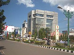
De Lambung Mangkurat-straat in nl:Banjarmasin. Overgenomen uit de Indonesische Wikipedia (publiek domein).
== Licencja ==Autor: Banjarmasin City, Licencja: CC BY-SA 4.0
Flag of Banjarmasin City, based on this image
Autor: Uwe Dedering, Licencja: CC BY-SA 3.0
Location map of Indonesia.
Equirectangular projection. Stretched by 100.0%. Geographic limits of the map:
- N: 6.5° N
- S: -11.5° N
- W: 94.5° E
- E: 141.5° E


