Baram
 | |
| Państwo | |
|---|---|
| Dystrykt | Północny |
| Wysokość | 725 m n.p.m. |
| Populacja • liczba ludności | 479 |
| Strona internetowa | |
| Portal | |
Baram (hebr. ברעם) – kibuc położony w samorządzie regionu Ha-Galil ha-Eljon, w Dystrykcie Północnym, w Izraelu.
Leży na północy Górnej Galilei, przy granicy z Libanem.
Członek Ruchu Kibuców (Ha-Tenu’a ha-Kibbucit).
Historia
Kibuc został założony w 1949 przez byłych żołnierzy Palmach.
Gospodarka
Gospodarka kibucu opiera się na sadownictwie. Z przemysłu znajduje się tutaj zakład produkujący sprzęt medyczny Elcam Medical.
Linki zewnętrzne
Media użyte na tej stronie
Autor: NordNordWest, Licencja: CC BY-SA 3.0
Flag of Israel. Shows a Magen David (“Shield of David”) between two stripes. The Shield of David is a traditional Jewish symbol. The stripes symbolize a Jewish prayer shawl (tallit).
Autor: MASQUERAID, Licencja: CC BY-SA 3.0
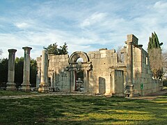
Ruins of the ancient synagogue in Kibbutz Bar'am in Northern Israel. The ruins are located within the site of the ancient village of Kfar Bar'am, about three kilometers from the Lebanese border.


