Barkingside (stacja metra)
 | |
| Państwo | |
|---|---|
| Miejscowość | Londyn |
| Dzielnica | Barkingside |
| Data otwarcia | 1903 |
| Liczba peronów | 2 |
| Central Line | |
| Poprzednia stacja | Newbury Park |
| Następna stacja | Fairlop |
Położenie na mapie gminy Redbridge  Contains Ordnance Survey data © Crown copyright and database right, CC BY-SA 3.0 | |
Położenie na mapie Wielkiej Brytanii  (c) Karte: NordNordWest, Lizenz: Creative Commons by-sa-3.0 de | |
Położenie na mapie Anglii  | |
Położenie na mapie Wielkiego Londynu  Contains Ordnance Survey data © Crown copyright and database right, CC BY-SA 3.0 | |
| Portal | |
Barkingside – stacja londyńskiego metra położona na trasie Central Line pomiędzy stacjami Newbury Park a Fairlop. Znajduje się w dzielnicy Barkingside w gminie London Borough of Redbridge, w czwartej strefie biletowej[1]. Stacja została otwarta w 1903 roku i początkowo obsługiwała linie kolejowe Great Eastern Railway, pierwsze pociągi metra Central Line rozpoczęły obsługę stacji 14 grudnia 1947[2] W 2010 roku obsłużyła 1,080 miliona pasażerów[3].
Połączenia
Stacja obsługiwana jest przez autobusy linii 169 i 247.
Galeria

Platfoma w kierunku wschodnim

Widok w kierunku południowym
Symbol stacji
 (c) Ben Brooksbank, CC BY-SA 2.0
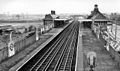
Stacja Barkingside, 1961
Przypisy
- ↑ Tube stations - Barkingside. Transport for London. [dostęp 2012-01-10].
- ↑ Central line facts (ang.). Transport For London. [dostęp 2012-01-10].
- ↑ Customer metrics: entries and exits (ang.). Transport For London. [dostęp 2012-01-04].
| Linia główna | |
|---|---|
| Odgałęzienie West Ruislip | |
| Odgałęzienie Ealing Broadway | |
| Odgałęzienie Woodford | |
| Odgałęzienie Epping |
![]()
Media użyte na tej stronie
(c) Karte: NordNordWest, Lizenz: Creative Commons by-sa-3.0 de
Location map of the United Kingdom

Blue Shield - the Distinctive emblem for the Protection of Cultural Property. The distinctive emblem is a protective symbol used during armed conflicts. Its use is restricted under international law.


(c) Ben Brooksbank, CC BY-SA 2.0
Barkingside Station.
View southward, towards Newbury Park and London: LT Central Line (Hainault Loop), since 31/5/48; until 29/11/47 this was the LNER (ex-GER) Fairlop Loop, Ilford - Woodford. Hence it is a typical Great Eastern station, little changed apart from the UndergrounD signs.

Autor: Sunil060902, Licencja: CC BY-SA 3.0
Barkingside tube station platform roundel
Contains Ordnance Survey data © Crown copyright and database right, CC BY-SA 3.0
Blank map of the London Borough of Redbridge, showing electoral wards.
Equirectangular map projection on WGS 84 datum, with N/S stretched 160%
Geographic limits:
- West: 0
- East: 0.16E
- North: 51.635N
- South: 51.535N

Autor: Sunil060902, Licencja: CC-BY-SA-3.0
Barkingside tube station looking north ('eastbound').
Autor: Sunil060902, Licencja: CC-BY-SA-3.0
Barkingside station building, opened 1903 by the GER
Contains Ordnance Survey data © Crown copyright and database right, CC BY-SA 3.0
Map of Greater London, UK with the following information shown:
- Administrative borders
- Coastline, lakes and rivers
- Roads and railways
- Urban areas
The data includes both primary routes and railway lines.
Equirectangular map projection on WGS 84 datum, with N/S stretched 160%
Geographic limits:
- West: 0.57W
- East: 0.37E
- North: 51.72N
- South: 51.25N

Autor: Sunil060902, Licencja: CC BY-SA 3.0
Barkingside tube station looking westbound (actually south here) from footbridge