Barnstaple
 Butchers' Row | |
| Państwo | |
|---|---|
| Kraj | |
| Hrabstwo | |
| Populacja (2006) • liczba ludności |
|
| Nr kierunkowy | 01271 |
| Kod pocztowy | EX31-EX32 |
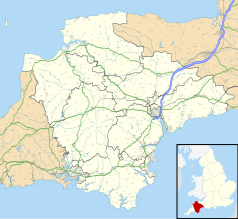
Położenie na mapie Devonu Contains Ordnance Survey data © Crown copyright and database right, CC BY-SA 3.0 | |
Położenie na mapie Wielkiej Brytanii (c) Karte: NordNordWest, Lizenz: Creative Commons by-sa-3.0 de | |
| Strona internetowa | |
| Portal | |
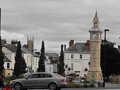
Barnstaple – miasto w południowo-zachodniej Anglii, w hrabstwie Devon, położone nad rzeką Taw.
Liczba ludności według stanu na kwiecień 2006 roku wynosi 34 000. Miasto jest głównym centrum szlaku turystycznego Tarka Trail[1]. W mieście znajduje się stacja kolejowa.
Miasta partnerskie
Barnstaple podpisało umowę z trzema miastami. Są to:
Demografia
Zgodnie z danymi z 2005 roku, 98,7% mieszkańców miasta jest narodowości brytyjskiej, 0,2% irlandzkiej, 0,2% mieszanej, 0,4% stanowią Chińczycy, a 0,5% inne narodowości.
Sport
W mieście znajduje się siedziba seniorskiego klubu rugby - Barnstaple RFC. Drużyna ta gra w południowo-zachodniej pierwszej lidze. Poza tym w Barnstaple istnieje klub piłkarski - Barnstaple Town FC oraz klub squash - Barnstaple Squash Club.
Urodzeni w Barnstaple
- Bruce Frederick Cummings (pseudonim artystyczny: W. N. P. Barbellion) - dziennikarz
- Francis Carruthers Gould - karykaturzysta i polityk
- Sir Francis Chichester - pilotarz i marynarz
- Giles Chichester - europejski polityk
- Marc Edworthy - piłkarz Derby County
- Sir Richard Eyre - reżyser teatralny, telewizyjny i filmowy
- John Gay - poeta i dramaturg
- Tim Wonnacott - antykwariusz i prezenter telewizyjny
- Tim Mills - były gitarzysta Iced Earth
- James Parsons - fizyk i antykwariusz
- Richard Roach Jewell - architekt
- Phil Vickery - rugbysta
- Snowy White - gitarzysta
- Carrie Davis - dziennikarz sportowy BBC Radio 1
- St. Cuthbert Mayne - ksiądz katolicki, męczennik
Linki zewnętrzne
- Oficjalna strona Barnstaple. barnstaple.co.uk. [zarchiwizowane z tego adresu (2019-10-12)].
Przypisy
- ↑ Tarka Trail – Braunton to Meeth. [dostęp 2009-12-05]. (ang.).
Media użyte na tej stronie
(c) Karte: NordNordWest, Lizenz: Creative Commons by-sa-3.0 de
Location map of the United Kingdom
Flag of England. Saint George's cross (a red cross on a white background), used as the Flag of England, the Italian city of Genoa and various other places.
The flag of Navassa Island is simply the United States flag. It does not have a "local" flag or "unofficial" flag; it is an uninhabited island. The version with a profile view was based on Flags of the World and as a fictional design has no status warranting a place on any Wiki. It was made up by a random person with no connection to the island, it has never flown on the island, and it has never received any sort of recognition or validation by any authority. The person quoted on that page has no authority to bestow a flag, "unofficial" or otherwise, on the island.
Contains Ordnance Survey data © Crown copyright and database right, CC BY-SA 3.0
Map of Devon, UK with the following information shown:
- Administrative borders
- Coastline, lakes and rivers
- Motorways and primary routes
- Urban areas
Equirectangular map projection on WGS 84 datum, with N/S stretched 150%
Geographic limits:
- West: 4.72W
- East: 2.86W
- North: 51.3N
- South: 50.16N


