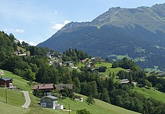
Bartholomäberg
 | |||
| |||
| Państwo | |||
|---|---|---|---|
| Kraj związkowy | |||
| Powiat | |||
| Powierzchnia | 27,19 km² | ||
| Wysokość | 1087 m n.p.m. | ||
| Populacja (1 stycznia 2015) • liczba ludności |
| ||
| • gęstość | 84 os./km² | ||
| Numer kierunkowy | 05556 | ||
| Kod pocztowy | 6781 | ||
| Tablice rejestracyjne | BZ | ||
Bartholomäberg – gmina w Austrii, w kraju związkowym Vorarlberg, w powiecie Bludenz. Liczy 2277 mieszkańców (1 stycznia 2015)[1].
Przypisy
Media użyte na tej stronie
Autor: Rosso Robot, Licencja: CC BY-SA 3.0
Location map of Vorarlberg
Equirectangular projection. Geographic limits of the map:
- N: 47.62 N
- S: 46.82 N
- W: 9.45 E
- E: 10.3 E
Autor: Lencer, Licencja: CC BY-SA 3.0
Location map of Austria
Equirectangular projection, N/S stretching 150 %. Geographic limits of the map:
- N: 49.2° N
- S: 46.3° N
- W: 9.4° E
- E: 17.2° E
de:Bartholomäberg, Vorarlberg: Ein durch Deichselschnitt geteilter Schild, vorne in Silber schwarze gekreuzte Schlüssel, hinten in Schwarz silberne gekreuzte Hämmer und oben in Rot auf grünem Dreiberg goldener hl. Bartholomäus mit Heiligenschein, der in der rechten Hand ein silbernes Messer, in der linken ein Gebetbuch hält. (Verleihung: 17. August 1965)
Autor: böhringer friedrich, Licencja: CC BY-SA 2.5
Blick über das Fritzentobel auf Bartholomäberg in Vorarlberg


