Basin (Wyoming)
Centrum Basin | |
| Państwo | |
|---|---|
| Stan | |
| Hrabstwo | |
| Data założenia | 1896 |
| Prawa miejskie | 1902 |
| Powierzchnia | 6,3[1] km² |
| Populacja (2010) • liczba ludności • gęstość |
|
| Nr kierunkowy | 307 |
| Kod pocztowy | 82410 |
| Portal | |
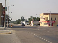
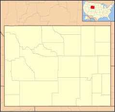
Basin – miasto (town), ośrodek administracyjny hrabstwa Big Horn, w północnej części stanu Wyoming, w Stanach Zjednoczonych, położone nad rzeką Bighorn[3]. W 2010 roku miasto liczyło 1285 mieszkańców[2].
Osada powstała w 1896 roku i otrzymała nazwę Basin City. W 1902 roku nastąpiło formalne założenie miasta, przemianowanego wówczas na Basin. Swoją nazwę miasto zawdzięcza położeniu na płaskowyżu Bighorn Basin[4].
Lokalna gospodarka opiera się na rolnictwie, przemyśle spożywczym (przetwórstwo buraków cukrowych, fasoli), górnictwie (wydobycie bentonitu) i turystyce[3].
Przypisy
- ↑ 2015 U.S. Gazetteer Files: Places: Wyoming (ang.). US Census Bureau. [dostęp 2017-07-02].
- ↑ a b Basin town, Wyoming (ang.). American FactFinder – US Census Bureau. [dostęp 2017-07-02]. [zarchiwizowane z tego adresu (2015-01-18)].
- ↑ a b Basin Overview (ang.). Town of Basin. [dostęp 2017-07-02].
- ↑ Town of Basin (ang.). [dostęp 2017-07-02].
Media użyte na tej stronie
Autor: Uwe Dedering, Licencja: CC BY-SA 3.0
Location map of the USA (without Hawaii and Alaska).
EquiDistantConicProjection:
Central parallel:
* N: 37.0° N
Central meridian:
* E: 96.0° W
Standard parallels:
* 1: 32.0° N
* 2: 42.0° N
Made with Natural Earth. Free vector and raster map data @ naturalearthdata.com.
Formulas for x and y:
x = 50.0 + 124.03149777329222 * ((1.9694462586094064-({{{2}}}* pi / 180))
      * sin(0.6010514667026994 * ({{{3}}} + 96) * pi / 180))
y = 50.0 + 1.6155950752393982 * 124.03149777329222 * 0.02613325650382181
      - 1.6155950752393982  * 124.03149777329222 *
     (1.3236744353715044  - (1.9694462586094064-({{{2}}}* pi / 180))
      * cos(0.6010514667026994 * ({{{3}}} + 96) * pi / 180))
The flag of Navassa Island is simply the United States flag. It does not have a "local" flag or "unofficial" flag; it is an uninhabited island. The version with a profile view was based on Flags of the World and as a fictional design has no status warranting a place on any Wiki. It was made up by a random person with no connection to the island, it has never flown on the island, and it has never received any sort of recognition or validation by any authority. The person quoted on that page has no authority to bestow a flag, "unofficial" or otherwise, on the island.
(c) CosmicPenguin z angielskiej Wikipedii, CC BY 2.5
Photograph of downtown Basin - Taken by Jordan Crouse on July 22, 2007
Ta ^specifik^ z W3C grafika wektorowa została stworzona za pomocą Inkscape.


