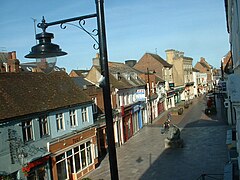
Basingstoke and Deane
| ||
| dystrykt niemetropolitalny | ||
(c) David Medcalf, CC BY-SA 2.0 Basingstoke | ||
| Państwo | ||
|---|---|---|
| Kraj | ||
| Region | South East England | |
| Hrabstwo | Hampshire | |
| Siedziba | Basingstoke | |
| Powierzchnia | 633,8 km² | |
| Populacja (2011) • liczba ludności | 167 799 | |
| • gęstość | 270 os./km² | |
| Położenie na mapie Hampshire Contains Ordnance Survey data © Crown copyright and database right, CC BY-SA 3.0 | ||
| Strona internetowa | ||
| Portal | ||
Basingstoke and Deane – dystrykt w hrabstwie Hampshire w Anglii. W 2011 roku dystrykt liczył 167 799 mieszkańców[1].
Miasta
Inne miejscowości
Adbury, Aldern Bridge, Ashe Warren, Ashford Hill, Ashford Hill with Headley, Ashley Warren, Ashmansworth, Axford, Axmansford, Baughurst, Bishop’s Green, Bradley, Bramley, Brimpton Common, Broadmere, Brown Candover, Burghclere, Charter Alley, Chineham, Cliddesden, Cole Henley, Deane, Dummer, East Woodhay, Ecchinswell, Ellisfield, Ewhurst, Farleigh Wallop, Hannington, Hare Warren, Hartley Wespall, Headley, Heath End, Herriard, Highclere, Hurstbourne Priors, Ibworth, Kingsclere, Laverstoke, Litchfield, Little London, Lower Woodcott, Mapledurwell, Mapledurwell and Up Nately, Mortimer West End, Moundsmere, Newnham, Newtown, North Waltham, Oakley, Oakridge, Old Basing, Overton, Pamber, Pamber End, Pamber Green, Pamber Heath, Preston Candover, Quidhampton, Ramsdell, St Mary Bourne, Sherborne St John, Sherfield on Loddon, Silchester, Steventon, Tufton, Tunworth, Up Nately, Upton Grey, Viables, Weston Corbett, Weston Patrick, Winslade, Wolverton Common, Wolverton, Woolton Hill, Wootton St Lawrence.
Przypisy
- ↑ Area: Basingstoke and Deane (Local Authority) (ang.). Neighbourhood Statistics (ONS). [dostęp 2016-04-24]. [zarchiwizowane z tego adresu (2016-10-03)].
Media użyte na tej stronie
Flag of England. Saint George's cross (a red cross on a white background), used as the Flag of England, the Italian city of Genoa and various other places.
Contains Ordnance Survey data © Crown copyright and database right, CC BY-SA 3.0
Map of Hampshire, UK with Basingstoke and Deane highlighted.
Equirectangular map projection on WGS 84 datum, with N/S stretched 155%(c) David Medcalf, CC BY-SA 2.0
London Road, Basingstoke


