Basra (muhafaza)
| prowincja | |||
 | |||
| |||
| Państwo | |||
|---|---|---|---|
| Siedziba | Basra | ||
| Powierzchnia | 19 070 km² | ||
| Populacja • liczba ludności | 2 600 000 | ||
| • gęstość | 136 os./km² | ||
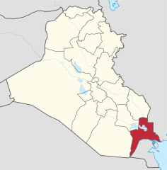
Położenie na mapie Iraku | |||
Basra (arab. البصرة = Al-Basra) – jedna z 18 prowincji Iraku. Znajduje się w południowej części kraju.
Występują bogate złoża ropy naftowej. Jest żyznym regionem rolniczym – ryż, kukurydza, jęczmień, proso, pszenica; hodowla zwierząt.
Media użyte na tej stronie
The local Iraqi construction crew is making progress on the new Shatt Al Arab Courthouse in Al Tonoma, Basrah Province.
Autor: TUBS
Location of province XY (see filename) in Iraq
Coat of arms of Iraq as adapted to new 2008 form of national flag -- standard pan-Arab "Eagle of Saladin" with shield of the tricolor of national flag (with the "Takbir" الله أكبر in Kufic text, as on the flag), holding a scroll with the words جمهورية العراق; (Jumhuriyat al-`Iraq "The Republic of Iraq").
Autor: MrPenguin20, Licencja: CC BY-SA 3.0
The flag of the Basra Governorate.


