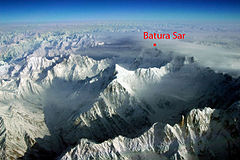
Batura Sar
 | |
| Państwo | |
|---|---|
| Położenie | Gilgit-Baltistan |
| Pasmo | Karakorum |
| Wysokość | 7795 m n.p.m. |
| Wybitność | 3118 m |
| Pierwsze wejście | 30 czerwca 1976 H. Bleicher, H. Oberhofer |
| • zimowe | niezdobyty |
Batura Sar (Batura I) – szczyt w Karakorum w masywie Batura Muztagh na terenie Pakistanu. To najwyższy szczyt grupy Batura Muztagh, najbardziej wysuniętego na zachód pasma Karakorum. Jest dwudziestym ósmym szczytem Ziemi pod względem wysokości.
Pierwszego wejścia dokonali 30 czerwca 1976 Hubert Bleicher i Herbert Oberhofer.
Linki zewnętrzne
- Rejon Batura (ang.)
Media użyte na tej stronie
Topografic map of the Tibetan Plateau in Asia.
- Bounding box West 66°, South 23°, East 108°, North 42°.
Autor: Uwe Dedering, Licencja: CC BY-SA 3.0
Relief Location map of Asia.
- Projection: Lambert azimuthal equal-area projection.
- Area of interest:
- N: 90.0° N
- S: -10.0° N
- W: 45.0° E
- E: 145.0° E
- Projection center:
- NS: 40.0° N
- WE: 95.0° E
- GMT projection: -JA95/50/20.0c
- GMT region: -R45.70461034279053/-25.193892806246794/-158.9850042825966/36.990936559512505r
- GMT region for grdcut: -R-20.0/-26.0/205.0/90.0r
- Relief: SRTM30plus.
- Made with Natural Earth. Free vector and raster map data @ naturalearthdata.com.
Black up-pointing triangle ▲, U+25B2 from Unicode-Block Geometric Shapes (25A0–25FF)
Autor:
- Batura_muztagh.jpg: Brian McMorrow
- derivative work: Fcarcena01 (talk)
Aerial photo of part of the Batura Muztagh in Pakistan, from the southeast. Sangemarmar in center of photo. Muchuhar Glacier on left, leading up to Hacindar Chhish. Batura Wall and Pasu Sar in clouds in center right. The notable rock spire at the bottom right is Bublimotin.


