Bavelincourt
| miejscowość i gmina | |
 | |
| Państwo | |
|---|---|
| Region | |
| Departament | |
| Okręg | |
| Kod INSEE | 80056[1] |
| Powierzchnia | 7,4 km²[2] |
| Populacja (2011) • liczba ludności |
|
| • gęstość | 17 os./km² |
| Kod pocztowy | 80260 |
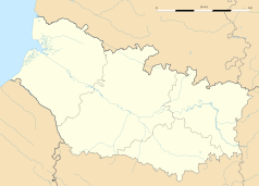
Położenie na mapie Sommy (c) Eric Gaba, Wikimedia Commons user Sting, CC BY-SA 3.0 | |
| Portal | |
Bavelincourt – miejscowość i gmina we Francji, w regionie Hauts-de-France, w departamencie Somma.
Według danych na rok 2011 gminę zamieszkiwało 129 osób, a gęstość zaludnienia wynosiła 17 osób/km²[3] (wśród 2293 gmin Pikardii Bavelincourt plasuje się na 923. miejscu pod względem liczby ludności, natomiast pod względem powierzchni na miejscu 656.).
Przypisy
- ↑ Kod INSEE na stronie francuskiego urzędu statystycznego (fr.)
- ↑ Statystyki na stronie francuskiego urzędu statystycznego (fr.)
- ↑ Populacja na stronie francuskiego urzędu statystycznego (fr.)
Media użyte na tej stronie
(c) Eric Gaba, Wikimedia Commons user Sting, CC BY-SA 3.0
Blank administrative map of the department of Somme, France, as in December 2014, for geo-location purpose, with distinct boundaries for regions, departments and arrondissements.
Autor: Superbenjamin, Licencja: CC BY-SA 4.0
Blank administrative map of France for geo-location purpose, with regions and departements distinguished. Approximate scale : 1:3,000,000
Autor: Flappiefh, Licencja: CC BY-SA 4.0
Carte administrative vierge de la région Hauts-de-France, France, destinée à la géolocalisation.
Autor: François Ansart, Licencja: CC BY-SA 3.0
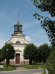
L'église de Bavelincourt a été construite entre 1848 et 1854. Sa façade est du style néo-classique, ornée de deux frontons triangulaires. L'édifice est en briques sur un soubassement de grès, hormis la façade, ainsi que la corniche, le bandeau et les pilastres décorant les murs latéraux, qui sont en craie.


