Baza lotnicza Ramon
 | |||||
| Państwo | |||||
|---|---|---|---|---|---|
| Miejscowość | Mitzpe Ramon | ||||
| Typ | wojskowe | ||||
| Właściciel | |||||
| Data otwarcia | 1981 | ||||
| Kod ICAO | LLRM | ||||
| Wysokość | 648 m n.p.m. | ||||
| Drogi startowe | |||||
| |||||
Baza Lotnicza Ramon – wojskowa baza Sił Powietrznych Izraela położona w pobliżu miasteczka Mitzpe Ramon, na pustyni Negew w południowej części Izrael.
Historia
Po wycofaniu się izraelskich wojsk z Półwyspu Synaj rząd Stanów Zjednoczonych udzielił pomocy finansowej i technicznej przy budowie nowych baz izraelskich sił powietrznych. W ten sposób w 1981 roku została wybudowana baza lotnicza Ramon[1].
Obecna eksploatacja
Na terenie bazy stacjonują oddziały specjalne jednostek Sayeret Moran i Sayeret Meitar. Istnieje tutaj ośrodek szkoleniowy Sayeret Meitar, który obejmuje szkołę i poligon rakiet przeciwczołgowych[1].
Eskadry
W bazie stacjonuje kilka eskadr:
- 107 Eskadra ("Rycerze Pomarańczowego Ogona") – samoloty wielozadaniowe F-16I Sufa,
- 113 Eskadra ("Szerszeń") – helikoptery szturmowe AH-64D Apache,
- 119 Eskadra ("Nietoperz") – samoloty wielozadaniowe F-16I Sufa,
- 146 Eskadra – bezzałogowe aparaty latające UAV Searcher i Hermes 450,
- 190 Eskadra ("Magiczne Dotknięcie") – helikoptery szturmowe AH-64 Apache,
- 253 Eskadra ("Negew") – samoloty wielozadaniowe F-16I Sufa.
Przypisy
Linki zewnętrzne
- Zdjęcie satelitarne bazy Google Maps
- Ramon Global Security
Media użyte na tej stronie
Flag of Israel. Shows a Magen David (“Shield of David”) between two stripes. The Shield of David is a traditional Jewish symbol. The stripes symbolize a Jewish prayer shawl (tallit).
Symbol lotniska do legendy mapy
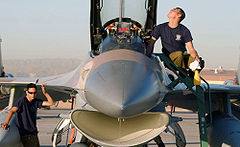
ISRAELI Air Force (IAF) F-16 Fighting Falcon aircraft Crew Chiefs, Master Sergeant (MSGT) Omar Terezzi (left) and IAF MSGT Koby Hazizia, conduct a preflight inspection of their aircraft during Exercise RED FLAG 2003, on the flight line at Nellis Air Force Base (AFB), Nevada (NV). Red Flag is currently the most realistic simulated air-warfare training exercise held anywhere in the world. It regularly involves the air forces of the United States and its allies.
Location: NELLIS AFB, NEVADA (NV) UNITED STATES OF AMERICA (USA)Roundel of the Israeli Air Force.
Autor: NordNordWest, Licencja: CC BY-SA 3.0


