Beauchastel
| miejscowość i gmina | |
 Beauchastel (2004) | |
| Państwo | |
|---|---|
| Region | |
| Departament | |
| Okręg | |
| Kod INSEE | 07027 |
| Powierzchnia | 8,45 km² |
| Populacja (1990) • liczba ludności |
|
| • gęstość | 173 os./km² |
| Kod pocztowy | 07800 |
Położenie na mapie Ardèche  | |
Położenie na mapie Francji  | |
Położenie na mapie regionu Owernia-Rodan-Alpy  | |
| Strona internetowa | |
| Portal | |
Beauchastel – miejscowość i gmina we Francji, w regionie Owernia-Rodan-Alpy, w departamencie Ardèche.
Według danych na rok 1990 gminę zamieszkiwały 1462 osoby, a gęstość zaludnienia wynosiła 173 osoby/km² (wśród 2880 gmin regionu Rodan-Alpy Beauchastel plasuje się na 580. miejscu pod względem liczby ludności, natomiast pod względem powierzchni na miejscu 1246.).
Galeria
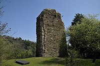
Ruiny Zamku Beauchastel (2010)

Starówka (2010)

Ratusz (2010)
Bibliografia
- Francuski urząd statystyczny. (fr.).
Linki zewnętrzne
- Oficjalna strona internetowa Beauchastel. beauchastel.com. [zarchiwizowane z tego adresu (2018-01-18)].
Media użyte na tej stronie
Ardeche department location map.svg
Autor: Flappiefh, Licencja: CC BY-SA 4.0
Blank administrative map of the department of Ardèche, France, for geo-location purpose.
Autor: Flappiefh, Licencja: CC BY-SA 4.0
Blank administrative map of the department of Ardèche, France, for geo-location purpose.
France location map-Regions and departements-2016.svg
Autor: Superbenjamin, Licencja: CC BY-SA 4.0
Blank administrative map of France for geo-location purpose, with regions and departements distinguished. Approximate scale : 1:3,000,000
Autor: Superbenjamin, Licencja: CC BY-SA 4.0
Blank administrative map of France for geo-location purpose, with regions and departements distinguished. Approximate scale : 1:3,000,000
Auvergne-Rhône-Alpes region location map.svg
Autor: Flappiefh, Licencja: CC BY-SA 4.0
Carte administrative vierge de la région Auvergne-Rhône-Alpes, France, destinée à la géolocalisation.
Autor: Flappiefh, Licencja: CC BY-SA 4.0
Carte administrative vierge de la région Auvergne-Rhône-Alpes, France, destinée à la géolocalisation.
.svg)

Reste de château de Beauchastel.jpg
Autor: Toutaitanous, Licencja: CC BY-SA 3.0
pan de mur du château
Autor: Toutaitanous, Licencja: CC BY-SA 3.0
pan de mur du château
_ruelle_en_escalier.JPG)
Beauchastel (Ardèche, Fr) ruelle en escalier.JPG
Autor: Havang(nl), Licencja: CC0
Beauchastel (Ardèche, Fr) ruelle en escalier.
Autor: Havang(nl), Licencja: CC0
Beauchastel (Ardèche, Fr) ruelle en escalier.
Beauchastel 2004-04-25 040.jpg
Autor: Sequajectrof Jacques Forêt, Licencja: CC BY-SA 4.0
view of the old village Beauchastel
Autor: Sequajectrof Jacques Forêt, Licencja: CC BY-SA 4.0
view of the old village Beauchastel
_mairie-%c3%a9cole.JPG)
Beauchastel (Ardèche, Fr) mairie-école.JPG
Autor: Havang(nl), Licencja: CC0
Beauchastel (Ardèche, Fr) mairie-école
Autor: Havang(nl), Licencja: CC0
Beauchastel (Ardèche, Fr) mairie-école