Beaulieu-sur-Dordogne
| miejscowość i gmina | |||
 Beaulieu-sur-Dordogne (2010) | |||
| |||
| Państwo | |||
|---|---|---|---|
| Region | |||
| Departament | |||
| Okręg | |||
| Kod INSEE | 19019 | ||
| Powierzchnia | 16,89 km² | ||
| Populacja (2013) • liczba ludności |
| ||
| • gęstość | 146 os./km² | ||
| Kod pocztowy | 19120 | ||
Położenie na mapie Corrèze  | |||
Położenie na mapie Francji  | |||
Położenie na mapie Nowej Akwitanii  | |||
| Strona internetowa | |||
| Portal | |||
Beaulieu-sur-Dordogne – miejscowość i gmina we Francji, w regionie Nowa Akwitania, w departamencie Corrèze. W 2013 roku populacja ówczesnej gminy wynosiła 1220 mieszkańców[1].
Dnia 1 stycznia 2019 roku połączono dwie wcześniejsze gminy: Beaulieu-sur-Dordogne oraz Brivezac. Siedzibą gminy została miejscowość Beaulieu-sur-Dordogne, a nowa gmina przyjęła jej nazwę[2].
Geografia
Beaulieu-sur-Dordogne znajduje się na południu departamentu Corrèze, nad brzegiem rzeki Dordogne. Powierzchnia gminy wynosi 16,89 km², gęstość zaludnienia wynosi 146 mieszkańców na km².
Poniższa mapa pokazuje lokalizację Beaulieu-sur-Dordogne, z główną infrastrukturą i sąsiadującymi gminami:

Populacja
Poniższa tabela przedstawia ewolucję liczby mieszkańców Beaulieu-sur-Dordogne w latach 1962–2008:

Atrakcje turystyczne
- Kościół opactwa Św. Piotra z romańskim tympanonem.
- Kaplica Penitentów nad brzegiem Dordonii.
- Zamek d'Estresse.
- Dom „Renesansowy” (fr. Maison Renaissance).
Galeria
 (c) Mussklprozz, CC-BY-SA-3.0
Beaulieu-sur-Dordogne nad brzegiem Dordonii
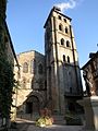
Dzwonnica kościoła opactwa Św. Piotra

Romański tympanon kościoła opactwa Św. Piotra
 © Raimond Spekking / CC BY-SA 4.0 (via Wikimedia Commons)
Nawa kościoła opactwa Św. Piotra

Zamek d'Estresse
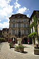
Maison Renaissance

Plac Bridolle

Maison Clare
 (c) Mussklprozz, CC-BY-SA-3.0
Kaplica Penitentów
Zobacz też
- Gminy w departamencie Corrèze
- Departament Corrèze
Przypisy
- ↑ Populations légales 2013 (fr.). INSEE. [dostęp 2020-04-12].
- ↑ Recueil des actes administratifs n°19-2018-038 : Arrêté n°19-2018-06-28-001 portant création de la commune nouvelle Beaulieu-sur-Dordogne (fr.). cher.gouv.fr. [dostęp 2020-04-12].
Media użyte na tej stronie
Autor: Flappiefh, Licencja: CC BY-SA 4.0
Blank administrative map of the department of Corrèze, France, for geo-location purpose.
Autor: Superbenjamin, Licencja: CC BY-SA 4.0
Blank administrative map of France for geo-location purpose, with regions and departements distinguished. Approximate scale : 1:3,000,000
Autor: Flappiefh, Licencja: CC BY-SA 4.0
Carte administrative vierge de la région Aquitaine-Limousin-Poitou-Charentes, France, destinée à la géolocalisation.
.svg)
.svg)
Autor: Jacques63, Licencja: CC BY-SA 3.0
coupé, au premier de gueules à l'enceinte fortifiée d'argent à trois tours crènelées et couvertes du même, ouvertes et ajourées de sable. au second, d'azur à un dextrochère d'argent mouvant du flanc senestre, tenant une clef du même posée en pal, le panneton en haut et débordant de la tige

Autor: A1AA1A, Licencja: CC BY-SA 4.0
This building is indexed in the base Mérimée, a database of architectural heritage maintained by the French Ministry of Culture, under the reference PA00099672

Autor: Nicolas.ehw, Licencja: CC BY-SA 3.0
This building is inscrit au titre des monuments historiques de la France. It is indexed in the base Mérimée, a database of architectural heritage maintained by the French Ministry of Culture, under the reference PA00099657

Autor: Hubert DENIES, Licencja: CC BY-SA 3.0
This building is indexed in the base Mérimée, a database of architectural heritage maintained by the French Ministry of Culture, under the reference PA00099668
Autor: Michiel1972, Licencja: CC BY-SA 3.0
Population - Municipality code 19272.svg
Population Census 1962-2008Autor:
|
Map data (c) OpenStreetMap contributors, CC-BY-SA _French_municipality_map.svg) • Shape files infrastructure: railway, highways, water: all originally by OpenStreetMap contributors. Status december 2011 *note: shown commune boundaries are from OSM dump May 2012; at that time about 90% complete |
Map commune FR insee code 19019.png

Autor: Père Igor, Licencja: CC BY-SA 4.0
La tour d'escalier de la maison Clare, rue Patata, Beaulieu-sur-Dordogne, Corrèze, France.
_Place_de_la_Bridolle_-_Maison_du_XVe_si%c3%a8cle.jpg)
Autor: GO69, Licencja: CC BY-SA 4.0
Maison du XVe siècle, Place de la Bridolle, à Beaulieu-sur-Dordogne (19).
_Abbatiale_Portail_M%c3%a9ridional_Tympan_08.jpg)
Autor: GO69, Licencja: CC BY-SA 4.0
Tympan du portail méridional de l'abbatiale Saint-Pierre de Beaulieu-sur-Dordogne (19).

© Raimond Spekking / CC BY-SA 4.0 (via Wikimedia Commons)
Abbatiale Saint-Pierre de Beaulieu-sur-Dordogne

Autor: O.Taris, Licencja: CC BY-SA 4.0
Beaulieu sur Dordogne, église Saint Pierre
