Bedford (borough)
| ||||
| ||||
 Siedziba władz Bedford | ||||
| Państwo | ||||
| Kraj | ||||
| Region | East of England | |||
| Hrabstwo | Bedfordshire | |||
| Siedziba | Bedford | |||
| Powierzchnia | 476,4 km² | |||
| Populacja (2011) • liczba ludności | 157 800 | |||
| • gęstość | 331 os./km² | |||
| Plan | ||||
Contains Ordnance Survey data © Crown copyright and database right, CC BY-SA 3.0 | ||||
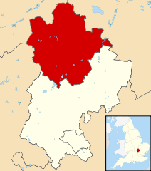
| Położenie na mapie Bedfordshire Contains Ordnance Survey data © Crown copyright and database right, CC BY-SA 3.0 | ||||
| Strona internetowa | ||||
| Portal | ||||
Bedford – dystrykt o statusie borough i unitary authority, w hrabstwie ceremonialnym Bedfordshire w południowej Anglii. Obejmuje miasto Bedford i otaczający je region.
Miasta
Inne miejscowości
Begwary, Biddenham, Bletsoe, Bolnhurst, Box End, Bromham, Cardington, Carlton, Chawston, Chellington, Clapham, Colesden, Colmworth, Cople, Cotton End, Duck's Cross, Duloe, Eastcotts, Elstow, Farndish, Felmersham, Great Barford, Great Denham, Harrold, Harrowden, Herrings Green, Hinwick, Honeydon, Keeley Green, Kempston Hardwick, Keysoe, Keysoe Row, Knotting Green, Knotting, Little Barford, Little Staughton, Lower Dean, Melchbourne, Milton Ernest, Oakley, Odell, Pavenham, Pertenhall, Podington, Radwell, Ravensden, Renhold, Riseley, Roxton, Salph End, Sharnbrook, Shelton, Shortstown, Souldrop, Stagsden, Staploe, Stevington, Stewartby, Swineshead, Thurleigh, Turvey, Upper Dean, Upper Staploe, West End, Wilden, Willington, Wilstead, Wood End, Wootton, Wyboston, Wymington, Yielden.
Media użyte na tej stronie
Flag of England. Saint George's cross (a red cross on a white background), used as the Flag of England, the Italian city of Genoa and various other places.
Borough Hall, Bedford, Bedfordshire from behind (the footpath by the river). The view is enhanced by the reflecting pool in the foreground (The building was formerly named County Hall).
Contains Ordnance Survey data © Crown copyright and database right, CC BY-SA 3.0
Map of Bedfordshire, UK with Bedford highlighted.
Equirectangular map projection on WGS 84 datum, with N/S stretched 160%Contains Ordnance Survey data © Crown copyright and database right, CC BY-SA 3.0
Map of Bedford, Bedfordshire, UK with electoral wards shown.
Equirectangular map projection on WGS 84 datum, with N/S stretched 160%
Geographic limits:
- West: 0.68W
- East: 0.20W
- North: 52.34N
- South: 52.04N


