Bedfordshire
| Hrabstwo ceremonialne | |||
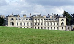
 Woburn Abbey, siedziba książąt Bedford | |||
| |||
| Państwo | |||
|---|---|---|---|
| Kraj | |||
| Region | |||
| Siedziba | |||
| Powierzchnia | 1235 km² | ||
| Populacja (2011) • liczba ludności |
| ||
| • gęstość | 498,1 os./km² | ||
| Szczegółowy podział administracyjny | |||
 | |||
| Liczba unitary authorities | 3 | ||
Położenie na mapie | |||
| Portal | |||
Bedfordshire – hrabstwo ceremonialne i historyczne we wschodniej Anglii, w regionie East of England, zaliczane do tzw. Home Counties. Do 2009 roku hrabstwo pełniło także funkcję administracyjną jako hrabstwo niemetropolitalne.
Powierzchnia hrabstwa wynosi 1235 km² a liczba ludności – 615 100 (2011)[1]. Największym miastem hrabstwa jest Luton, w sąsiedztwie którego znajduje się międzynarodowy port lotniczy Londyn-Luton. Drugie pod względem wielkości jest Bedford, dawna stolica hrabstwa. Inne większe miasta na terenie Bedfordshire to Leighton Buzzard oraz Dunstable.
Na wschodzie Bedfordshire graniczy z hrabstwem Cambridgeshire, na południu z Hertfordshire, na zachodzie z Buckinghamshire a na północy z Northamptonshire.
Podział administracyjny
Obecny
W skład hrabstwa wchodzą trzy jednostki administracyjne typu unitary authority:
Do 2009
Przed reformą administracyjną przeprowadzoną w 2009 roku Bedfordshire było hrabstwem niemetropolitalnym, w którego skład wchodziły trzy dystrykty. Jako hrabstwo ceremonialne Bedfordshire obejmowało wówczas dodatkowo jedną jednostkę typu unitary authority.
- Bedford
- Mid Bedfordshire
- South Bedfordshire
- Luton (unitary authority)
Mapa
Uwagi
- ↑ Stolica Bedfordshire do 2009 roku, gdy hrabstwo przestało pełnić funkcję administracyjną.
Przypisy
- ↑ Table P04 2011 Census: Usual resident population by five-year age group, local authorities in England and Wales. Office for National Statistics. [dostęp 2012-07-24]. (ang.).
- ↑ Office for National Statistics: KS101EW - Usual resident population. [w:] 2011 Census [on-line]. Nomis – Official labour market statistics, 2013-02-12. [dostęp 2022-06-05]. (ang.).
- ↑ Office for National Statistics: Built-up Area to Local Authority District (December 2011) Lookup in England and Wales. [w:] Open Geography Portal [on-line]. [dostęp 2022-06-05]. (ang.).
- ↑ Office for National Statistics: Built-up Area Sub Divisions (December 2011) Boundaries. [w:] Open Geography Potal [on-line]. [dostęp 2022-06-05]. (ang.).
Bibliografia
- Bedfordshire, [w:] Encyclopædia Britannica [online] [dostęp 2012-03-07] (ang.).
Media użyte na tej stronie
Flag of England. Saint George's cross (a red cross on a white background), used as the Flag of England, the Italian city of Genoa and various other places.
The flag of the historic county of Bedfordshire, registered by the Flag Institute, September 2014
Autor: Nilfanion, Licencja: CC BY-SA 3.0
Location of the ceremonial county of Bedfordshire within England.
Contains Ordnance Survey data © Crown copyright and database right, CC BY-SA 3.0
Map of Bedfordshire, UK with the following information shown:
- Administrative borders
- Coastline, lakes and rivers
- Motorways, primary routes and railways
- Urban areas
Equirectangular map projection on WGS 84 datum, with N/S stretched 160%
Geographic limits:
- West: 0.8W
- East: 0.05W
- North: 52.33N
- South: 51.8N


