Besançon
 | |||||
| Państwo | |||||
|---|---|---|---|---|---|
| Region | |||||
| Departament | |||||
| Mer | Anne Vignot (EELV) | ||||
| Powierzchnia | 65,05 km² | ||||
| Wysokość | 281 m n.p.m. | ||||
| Populacja (2016) • liczba ludności • gęstość |
| ||||
| Kod pocztowy | 25000 | ||||
| Strona internetowa | |||||
| Portal | |||||
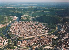
Besançon – miejscowość i gmina we wschodniej Francji, położona w pobliżu granicy ze Szwajcarią, stolica regionu Burgundia-Franche-Comté i departamentu Doubs.
Pierwsza wzmianka o mieście pochodzi z 58 roku p.n.e., z Księgi Pierwszej O wojnie galijskiej Juliusza Cezara, w której wspomina on o osadzie Vesontio. W IV w. n.e. nazwa zmieniła się na Besontio lub Bisontion. W 1243 r. miasto przyjęło nazwę Besançon.
Według danych na rok 2016 gminę zamieszkiwało 116 466 osób, a gęstość zaludnienia wynosiła 1 790 osób/km² (wśród 1 786 gmin Franche-Comté Besançon plasuje się na 1. miejscu pod względem liczby ludności, natomiast pod względem powierzchni na miejscu 3.).
W mieście znajduje się stacja kolejowa Gare de Besançon-Viotte i jedno z najstarszych publicznych muzeów we Francji: Muzeum Sztuk Pięknych i Archeologii w Besançon. Besançon to duże miasto studenckie i siedziba Université de Franche-Comté.
Zabytki
- synagoga w Besançon
- cmentarz żydowski w Besançon
- więzienie w Besançon
Edukacja
- École nationale supérieure de mécanique et des microtechniques
Urodzeni w Besançon
- Emil Andreoli – uczestnik powstania styczniowego
- Victor Hugo – pisarz
- Bracia Lumière – wynalazcy
- Pierre-Joseph Proudhon – polityk i anarchista
- Charles Fourier – socjalista utopijny, twórca terminu „feminizm”
Miasta partnerskie
 Twer, Rosja
 Fryburg Bryzgowijski, Niemcy
 Kuopio, Finlandia
 Huddersfield, Wielka Brytania
 Bielsko-Biała, Polska
 Neuchâtel, Szwajcaria
 Bistriţa, Rumunia
 Pawia, Włochy
 Hadera, Izrael
 Douroula, Burkina Faso
 Man, Wybrzeże Kości Słoniowej
 Charlottesville, USA

Bibliografia
- Francuski urząd statystyczny. (fr.).
Media użyte na tej stronie
Autor: Superbenjamin, Licencja: CC BY-SA 4.0
Blank administrative map of France for geo-location purpose, with regions and departements distinguished. Approximate scale : 1:3,000,000
Autor: Flappiefh, Licencja: CC BY-SA 4.0
Carte administrative vierge de la région Bourgogne-Franche-Comté, France, destinée à la géolocalisation.
Flaga Finlandii
Flag of Israel. Shows a Magen David (“Shield of David”) between two stripes. The Shield of David is a traditional Jewish symbol. The stripes symbolize a Jewish prayer shawl (tallit).
Flag of the Ivory Coast, written by Jon Harald Søby, modified by Zscout370. The colors match to what is reported at http://fotw.vexillum.com/flags/ci.html.
The flag of Navassa Island is simply the United States flag. It does not have a "local" flag or "unofficial" flag; it is an uninhabited island. The version with a profile view was based on Flags of the World and as a fictional design has no status warranting a place on any Wiki. It was made up by a random person with no connection to the island, it has never flown on the island, and it has never received any sort of recognition or validation by any authority. The person quoted on that page has no authority to bestow a flag, "unofficial" or otherwise, on the island.
Autor: Jean-Pol GRANDMONT, Licencja: CC BY-SA 3.0
Besançon (Doubs - France), the Doubs river, the Tour de la Pelote and the Quai Vauban with the former granaries of the city seen from the Pont Battant.
Autor: Flappiefh, Licencja: CC BY-SA 4.0
Blank administrative map of the department of Doubs, France, for geo-location purpose.
Autor: Geraldiker, Licencja: CC BY-SA 4.0
Flag of the administrative region Bourgogne-Franche-Comté (with the gobbony error shown on the actual flag)


