Bideford
(c) Tony Atkin, CC BY-SA 2.0 Panorama miasta | |
| Państwo | |
|---|---|
| Kraj | |
| Hrabstwo | |
| Dystrykt | |
| Populacja (2002) • liczba ludności |
|
| Nr kierunkowy | 01237 |
| Kod pocztowy | EX39 |
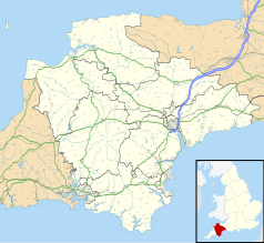
Położenie na mapie Devonu Contains Ordnance Survey data © Crown copyright and database right, CC BY-SA 3.0 | |
Położenie na mapie Wielkiej Brytanii (c) Karte: NordNordWest, Lizenz: Creative Commons by-sa-3.0 de | |
| Strona internetowa | |
| Portal | |
Bideford – miasto portowe w Wielkiej Brytanii, w hrabstwie Devon, w dystrykcie Torridge, położone nad rzeką Torridge. Miasto leży na szlaku turystycznym Tarka Trail[1].
Historia
Ośrodek handlowy, prawo do targu zagwarantowane w 1272. W XIII wieku wybudowano tu most zwany "długim" (Long Bridge), opartym na 24 łukach, istniejącym do dzisiaj. W XVI wieku miasto rozrosło się do rozmiarów trzeciego pod względem wielkości portu w Wielkiej Brytanii[2]. Port zajmował się przede wszystkim załadunkiem gliny na statki. Według legendy, to tu właśnie sir Walter Raleigh miał wyładować swój pierwszy ładunek handlowy[3]. Obecnie miasto pełni rolę lokalnego ośrodka handlowego.
W 2008 poddano remontowi zabytkowy most, za kwotę 2,1 mln GBP[4].
Bideford w kulturze
Miasto było miejscem zamieszkania dziewiętnastowiecznego literata Charlesa Kingsleya. Autor opisał Bideford w książce Westward Ho!, od jej tytułu nazwano sąsiadujące miasto. W miejscowym parku znajduje się pomnik pisarza.
Miasta partnerskie
![]() Manteo, North Carolina.
Manteo, North Carolina.
Przypisy
- ↑ Tarka Trail – Braunton to Meeth (ang.). [dostęp 2009-12-05].
- ↑ Bideford Devon. [dostęp 2008-09-15].
- ↑ Bideford, Devon (ang.). [dostęp 2008-09-15]. [zarchiwizowane z tego adresu (2008-05-16)].
- ↑ £2.1 million repairs to Bideford Long Bridge due to begin (ang.). [dostęp 2008-09-15].
Media użyte na tej stronie
(c) Karte: NordNordWest, Lizenz: Creative Commons by-sa-3.0 de
Location map of the United Kingdom
Flag of England. Saint George's cross (a red cross on a white background), used as the Flag of England, the Italian city of Genoa and various other places.
The flag of Navassa Island is simply the United States flag. It does not have a "local" flag or "unofficial" flag; it is an uninhabited island. The version with a profile view was based on Flags of the World and as a fictional design has no status warranting a place on any Wiki. It was made up by a random person with no connection to the island, it has never flown on the island, and it has never received any sort of recognition or validation by any authority. The person quoted on that page has no authority to bestow a flag, "unofficial" or otherwise, on the island.
Contains Ordnance Survey data © Crown copyright and database right, CC BY-SA 3.0
Map of Devon, UK with the following information shown:
- Administrative borders
- Coastline, lakes and rivers
- Motorways and primary routes
- Urban areas
Equirectangular map projection on WGS 84 datum, with N/S stretched 150%
Geographic limits:
- West: 4.72W
- East: 2.86W
- North: 51.3N
- South: 50.16N


