Bifröst (miejscowość)
 Widok na kampus uczelni tworzący miejscowość Bifröst | |
| Państwo | |
|---|---|
| Okręg wyborczy | Norðvesturkjördæmi |
| Region | Vesturland |
| Okręg historyczny | Mýrasýsla |
| Gmina | Borgarbyggð |
| Populacja (2018) • liczba ludności | 179[1] |
Położenie na mapie Islandii  | |
| Strona internetowa | |
Bifröst – miejscowość w zachodniej Islandii, w dolinie rzeki Norðurá, w sąsiedztwie jeziora Hreðavatn, około 30 km na północny wschód od Borgarnes[2]. Położona jest w gminie Borgarbyggð, w regionie Vesturland. Przez miejscowość przebiega okrążająca Islandię droga 1[2]. Na początku 2018 roku zamieszkiwało ją 179 osób[1].
Jest osadą uniwersytecką, która powstała po przeniesieniu tutaj w 1955 roku z Reykjavíku prywatnej uczelni, współcześnie znanej jako Uniwersytet w Bifröst (isl. Háskólinn á Bifröst). Z czasem na terenie dawnej farmy powstał kampus uczelni, na którym obecnie można znaleźć sklep, kawiarnię, siłownię, saunę, tereny sportowe i żłobek. Szkoła podstawowa znajduje się w pobliskiej osadzie Varmaland[3].
Grábrókarhraun
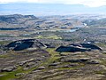
Bifröst otoczony jest liczącym 3000 lat polem lawy Grábrókarhraun, porośniętym mchem i wrzosem. Tuż za kampusem uniwersytetu znajduje się stary wulkan Grábrók i kolejna góra, Grábrókarfell[4].

Wrzosowiska i obszary leśne na południe od Bifröst
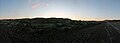
Panorama Grábrókarhraun o świcie, listopad 2007
Grábrók i Grábrókarfell

Bifröst otoczony polem lawy Grábrókarhraun
Przypisy
- ↑ a b Municipalities and urban nuclei (ang.). Hagstofa Íslands. [dostęp 2018-11-24].
- ↑ a b Map Viewer (ang.). National Land Survey of Iceland. [dostęp 2018-11-24].
- ↑ History (ang.). bifrost.is. [dostęp 2018-11-24].
- ↑ Háskólinn á Bifröst - Forsíða, 19 lipca 2011 [dostęp 2018-11-25] [zarchiwizowane z adresu 2011-07-19].
Media użyte na tej stronie

Der Campus der Universität Bifröst

(c) Debivort at en.wikipedia, CC BY-SA 3.0
Heading toward Bifröst, east of Varmaland, November 21 09:50
Iceland, November 2007
Photo by me user debivort (or friend, with permission given to upload and license freely).
Autor: Theotherguydidit, Licencja: CC BY 3.0
Grábrók til the left and Grábrókarfell to the right

(c) Debivort at en.wikipedia, CC BY-SA 3.0
Panorama of Grábrókarhraun, the 3,000 year old heather-encrusted lavafield just south of Bifröst, November 21 10:00
Iceland, November 2007
Photo by me user debivort (or friend, with permission given to upload and license freely).
(c) Debivort at en.wikipedia, CC BY-SA 3.0
North over Grábrókarhraun toward Baula (934m) and the town of Bifröst, November 21 10:05
Iceland, November 2007
Photo by me user debivort (or friend, with permission given to upload and license freely).