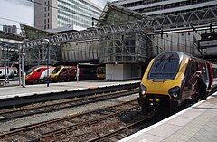
Birmingham New Street
| ||
 | ||
| Państwo | ||
| Kraj | ||
| Miejscowość | Birmingham | |
| Data otwarcia | 1854 | |
| Dane techniczne | ||
| Liczba peronów | 6 | |
| Liczba krawędzi peronowych | 12 | |
| Kasy | ||
| Linie kolejowe | ||
Położenie na mapie Birmingham Contains Ordnance Survey data © Crown copyright and database right, CC BY-SA 3.0 | ||
Położenie na mapie Wielkiej Brytanii (c) Karte: NordNordWest, Lizenz: Creative Commons by-sa-3.0 de | ||
Położenie na mapie West Midlands Contains Ordnance Survey data © Crown copyright and database right, CC BY-SA 3.0 | ||
| Portal | ||
Birmingham New Street – największa stacja kolejowa w Birmingham, w Anglii. Położona jest w centrum miasta. Ma 6 peronów i obsługuje rocznie 14,221 mln pasażerów.
Liczba pociągów kursujących od poniedziałku do soboty poza szczytem, w pociągach na godzinę (p/hr)
Przewoźnik:Virgin Trains [1]
- 3 p/hr London Euston przez Coventry
- 1 p/hr Glasgow Central lub Edynburg do Waverley (na zmianę) przez Preston do i Carlisle.
Przewoźnik: CrossCountry [2]
- 2 p/hr Manchester Piccadilly przez Stafford i Stoke-on-Trent.
- 2 p/hr Bristol Temple Meads, jeden z nich kontynuuje jazdę do Plymouth, niektóre jadą dalej, nawet do Penzance.
- 2 p/hr Nottingham przez Derby.
- 2 p/hr Leicester, jeden z nich kontynuuje jazdę do Stansted Airport przez Peterborough.
- 2 p/hr Reading przez Oxford, niektóre jadą dalej do Southampton Central i Bournemouth.
- 1 p/hr Cardiff Central przez Gloucester i Newport.
- 1 p/hr Newcastle Central przez Sheffield i Doncaster.
- 1 p/hr Edynburg Waverley przez Leeds i Newcastle Central, kontynuują na zmianę do Glasgow Central lub Dundee i Aberdeen.
Przewoźnik: London Midland [3]
- 3 p/hr Longbridge
- 3 p/hr Redditch
- 2 p/hr Four Oaks
- 2 p/hr Lichfield City
- 2 p/hr Lichfield Trent Valley
- 2 p/hr Wolverhampton
- 3 p/hr Walsall
- 1 p/hr Rugeley Trent Valley
- 3 p/hr London Euston przez Coventry i Northampton
- 2 p/hr Liverpool Lime Street przez Crewe
- 1 p/hr Birmingham International
- 1 p/hr Hereford przez Bromsgrove i Worcester Foregate Street
- 1 p/hr Shrewsbury
Przewoźnik: Arriva Trains Wales [4]
- 1 p/hr Birmingham International
- 1 p/hr Shrewsbury, kontynuują na zmianę do Chester i Holyhead lub Aberystwyth/Pwllheli
Media użyte na tej stronie
(c) Karte: NordNordWest, Lizenz: Creative Commons by-sa-3.0 de
Location map of the United Kingdom
Flag of England. Saint George's cross (a red cross on a white background), used as the Flag of England, the Italian city of Genoa and various other places.
Autor: MGalloway (WMF), Licencja: CC BY-SA 3.0
A tickmark icon included in the OOjs UI MediaWiki lib.
Contains Ordnance Survey data © Crown copyright and database right, CC BY-SA 3.0
Map of the West Midlands, UK with the following information shown:
- Administrative borders
- Coastline, lakes and rivers
- Roads and railways
- Urban areas
Equirectangular map projection on WGS 84 datum, with N/S stretched 160%
Geographic limits:
- West: 2.22W
- East: 1.40W
- North: 52.68N
- South: 52.33N
Autor: mattbuck (category), Licencja: CC BY-SA 3.0
Virgin Trains Pendolino 390016, CrossCountry Voyagers 220014 (background) and 221133 (foreground) and London Midland 323212 at Birmingham New Street.
Contains Ordnance Survey data © Crown copyright and database right, CC BY-SA 3.0
Map of Birmingham, West Midlands, UK with electoral wards shown.
Equirectangular map projection on WGS 84 datum, with N/S stretched 160%
Geographic limits:
- West: 2.05W
- East: 1.72W
- North: 52.62N
- South: 52.37N
Autor: MGalloway (WMF), Licencja: CC BY-SA 3.0
A tickmark icon included in the OOjs UI MediaWiki lib.


