Bitwa morska w cieśninie Solent
| Wojna angielsko-francuska 1544–1550 | |||
 Bitwa w cieśninie Solent | |||
| Czas | 19 lipca 1545 | ||
|---|---|---|---|
| Miejsce | |||
| Terytorium | |||
| Wynik | Bez rozstrzygnięcia | ||
| Strony konfliktu | |||
| |||
| Dowódcy | |||
| |||
| Siły | |||
| |||
| Straty | |||
| |||
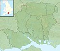
Położenie na mapie Hampshire Contains Ordnance Survey data © Crown copyright and database right, CC BY-SA 3.0 | |||
| 50°46′39″N 1°13′35″W/50,777500 -1,226389 | |||
Bitwa morska w cieśninie Solent – starcie zbrojne, które miało miejsce w roku 1545.
W lipcu 1545 r. flota francuska pod wodzą adm. Claude d'Annebaulta krążąca po kanale La Manche nawiązała kontakt ze stacjonującą w pobliżu Portsmouth flotą angielską admirała Lisleya. Do manewrów obu stron doszło 18 lipca w cieśninie Solent w rejonie mielizny Spitsand[1]. W jej trakcie, Mary Rose wykonała ostry zwrot mając otwarte furty działowe, przez które do wewnątrz dostały się duże ilości wody. W efekcie okręt szybko zatonął razem z 400 osobami załogi[2]. Równocześnie Francuzi zawzięcie zaatakowali flagowy okręt angielski Henry Grace a Dieu. Flota francuska ostatecznie wycofała się i bitwa nie została rozstrzygnięta[1].
Przypisy
- ↑ a b Zygmunt Ryniewicz: Leksykon bitew świata, Wyd. Almapress, Warszawa 2004
- ↑ Krzysztof Kowalski: Życie codzienne spod wody. www.rp.pl, 2009-10-23. [dostęp 2018-08-10].
Media użyte na tej stronie
Autor: Alexrk2, Licencja: CC BY-SA 3.0
Location map of the United Kingdom
zwei stilisierte gekreuzte Schwerter als Zeichen zur Nutzung in Karten, in der Genealogie, etc.; Unicode-Zeichen U+2694
The Cowdray engraving of the battle of the Solent, 1545.
The encampment of the English forces near Portsmouth, together with a view of the English and French fleets at the commencement of the action between them on the XIXst of July MDXLV, by James Basire, engraved from a coeval painting, at Cowdray in Sussex, the Seat of Lord Viscount Montague.
The Cowdray engravings are a set of images recording Henry VIII’s campaign in France during the summer of 1544 and the events of 19th July 1545 in Portsmouth, the Solent and the Isle of Wight, showing the attempt by the forces of the French King, Francis 1st, to invade England and wrest the crown from Henry. One of the most notable events that occurred during the “Battle of the Solent” was the loss of King Henry VIII’s vice flagship, the Mary Rose, and her sinking is clearly shown in this picture.Contains Ordnance Survey data © Crown copyright and database right, CC BY-SA 3.0
Relief map of Hampshire, UK.
Equirectangular map projection on WGS 84 datum, with N/S stretched 155%
Geographic limits:
- West: 2.01W
- East: 0.68W
- North: 51.41N
- South: 50.68N
Autor: Nilfanion, Licencja: CC BY-SA 3.0
Relief map of England, UK.
Equirectangular map projection on WGS 84 datum, with N/S stretched 170%
Geographic limits:
- West: 6.75W
- East: 2.0E
- North: 56.0N
- South: 49.75N


