Bitwa o wyspę Saint Lucia
| ||||
| ||||
 Bitwa o Saint Lucia | ||||
| Czas | 13-29 grudnia 1778 | |||
| Miejsce | Saint Lucia | |||
| Terytorium | Małe Antyle | |||
| Wynik | Zwycięstwo Anglików | |||
| Strony konfliktu | ||||
|---|---|---|---|---|
| ||||
| Dowódcy | ||||
| ||||
| Siły | ||||
| ||||
| Straty | ||||
| ||||
| 14,017000°N 60,983000°W/14,017000 -60,983000 | ||||
Bitwa o wyspę Saint Lucia – operacje desantowe i bitwa morska u brzegów wyspy w grudniu 1778, w czasie wojny o niepodległość Stanów Zjednoczonych, zakończone zdobyciem wyspy przez siły brytyjskie adm. Barringtona i gen. Jamesa Granta[1].
W listopadzie 1778 eskadra angielska (5 okrętów liniowych komodora Williama Hothama i transportowce z 5 tys. żołnierzy) wyruszyła z Nowego Jorku na Barbados. W tym samym czasie eskadra francuska adm. Charlesa Henri d’Estainga (12 okrętów) wyruszyła z Bostonu; obie floty płynęły równolegle nie wiedząc o swoim istnieniu, aż 25 listopada d’Estaing przechwycił jeden z brytyjskich transportowców. Nie znając dokładnego celu brytyjskiej eskadry, skierował się najpierw ku wyspie Antigua[2].
Hotham połączył się na Barbadosie z adm. Samuelem Barringtonem, który natychmiast wyruszył ku francuskiej wyspie Saint Lucia. 13 grudnia wysadzili na wyspie desant, który opanował nadbrzeżne baterie, a następnego dnia, działając szybko i energicznie, także stolicę wyspy. Dużo słabszy francuski garnizon wycofał się w głąb wyspy. Brytyjczycy ustawili baterie dział, okopując się na lądzie w pobliżu wejścia do zatoki Grand Cul de Suc. Równocześnie, Barrington, ostrzeżony o nadciągającej eskadrze d’Estainga, przygotował się do obrony, ustawiając okręty w linię w poprzek wejścia do zatoki, ze skrzydłami chronionymi przez nadbrzeżne baterie, a transportowce kotwicząc w głębi, za linią obronną[2].
15 grudnia o godz. 11.30 okręty francuskie zaatakowały eskadrę brytyjską. Francuzi przepłynęli wzdłuż szyku angielskiego, ale wymiana ognia była mało skuteczna (3 zabitych po stronie brytyjskiej, minimalne straty po francuskiej). D’Estaing wysadził następnie desant (7 000 ludzi) na północ od pozycji angielskich. 18 grudnia oddział francuski pod osobistym dowództwem D’Estainga zaatakował pozycje angielskie, ale po trzech szturmach i stracie 41 oficerów i 800 żołnierzy rannych i zabitych, wycofali się. Francuski admirał czekał jeszcze czas jakiś na silniejszy wiatr, który pozwoliłby mu zaatakować eskadrę brytyjską, ale Barrington zwarł mocniej szyk i osłonił flotę bateriami ciężkich dział zdjętych z okrętów, co spowodowało, że Francuzi zrezygnowali i 29 grudnia odpłynęli z wyspy. Garnizon francuski skapitulował następnego dnia. Wyspa pozostała w rękach brytyjskich do końca wojny, zapewniając wygodne kotwicowisko, nieodległe (30 mil) od głównej angielskiej bazy, Port Royal[2].
Przypisy
- ↑ Paweł Piotr Wieczorkiewicz: Historia wojen morskich. T. 1: Wiek żagla. Warszawa: Wydawnictwo Puls, 1995, s. 352-353. ISBN 1-85917-030-7.
- ↑ a b c Alfred Thayer Mahan: Major operations of the royal navy, 1762-1783. Boston: Little, Brown, and company, 1898, s. 428-432.
Media użyte na tej stronie
Symbol miejsca bitwy do legendy mapy
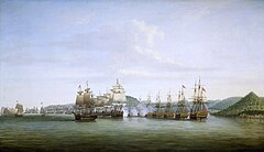
Barrington's Action at St Lucia, 15 December 1778
When France allied herself with the American rebels in 1778, during the American Revolutionary War, the naval commander-in-chief in the West Indies, Rear-Admiral Samuel Barrington, moved very swiftly against the French island of St Lucia. He had been joined by Commodore Hotham on 10 December whose squadron brought him 5000 troops. Sailing on 12 December he landed his men on the beaches of the Grand Cul de Sac on the west side of the island, which was lightly held by the French. Barrington disposed his ships at anchor in a defensive line off the mouth of the bay, to cover the landing and the transports. The troops made a rapid advance into the interior and most of the island was secured by the afternoon of the 15th.
This coincided with the arrival of Admiral d'Estaing and the French West Indies fleet, which included 12 ships of the line and which immediately attacked the anchored line of British ships in an effort to displace them and destroy the transports sheltering inshore. Barrington had, however, placed his ships well and had no difficulty rebuffing this brief assault. D'Estaing then landed 7000 troops on the 17th at a bay just north of the Grand Cul de Sac but his attempts to storm the higher British positions were repulsed with heavy loss of life. He then waited twelve days for conditions to favour a renewed attack on Barrington's ships, which improved their defensive positions in the interval. By 29 December the wind conditions were still unfavourable so d'Estaing quit the island and the embattled French governor surrendered the following day.
On the right is the southern point of the Grand Cul de Sac, with the 'Prince of Wales', in port-quarter view anchored off it, sternmost of the British line. Only the three leading British ships are in action and the wind conditions are forcing the French line to break away before they can engage the sternmost ships. In fact, the conditions did not permit the French to get as close to the British line as the picture indicates. On the left picture are several small vessels wearing the flag of the American rebel forces and early forms of the 'Stars and Stripes'.
This picture is one of a pair commissioned by Barrington and is signed and dated 'D Serres 1780'. The other, which shows the British fleet at anchor after the action, has recently been reunited with it in the Museum's collection (ZBA2204). Both were exhibited at the Royal Academy in 1780.
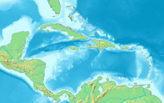
Map of the Caribbean and Central America.
Bounding box West -93°, South 7°, East -58°, North 28°.
Center at 17°30′00″N 75°30′00″W / 17.50000°N 75.50000°W.


