Bjurakan
 | |
| Państwo | |
|---|---|
| Prowincja | |
| Populacja (2011) • liczba ludności |
|
Położenie na mapie Armenii (c) Karte: NordNordWest, Lizenz: Creative Commons by-sa-3.0 de | |
| 40°20′24″N 44°16′13″E/40,340000 44,270278 | |
Bjurakan – wieś w Armenii, w prowincji Aragacotn. W 2011 roku liczyła 4345 mieszkańców.
Kontrola autorytatywna (village in Armenia):
Media użyte na tej stronie
Armenia adm location map.svg
(c) Karte: NordNordWest, Lizenz: Creative Commons by-sa-3.0 de
Location map of Armenia
(c) Karte: NordNordWest, Lizenz: Creative Commons by-sa-3.0 de
Location map of Armenia
Aragatsotn.svg
Autor:
Image shows the eleven administrative subdivisions of Armenia: # Aragatsotn (Արագածոտնի) # Ararat (Արարատի) # Armavir (Արմավիրի) # Gegharkunik (Գեղարքունիքի) # Kotayk (Կոտայքի) # Lori (Լոռու) # Shirak (Շիրակի) # Syunik (Սյունիքի) # Tavush (Տավուշի) # Vayots Dzor (Վայոց Ձորի) # Yerevan (Երևան) - special administrative status Derived from a multiple of public sources and created using Inkscape. ==
Autor:
- Armenia_template.svg: *Armenia_map_numbered.svg: Bastique
- derivative work: Varmin (talk)
- derivative work: Varmin (talk)
Image shows the eleven administrative subdivisions of Armenia: # Aragatsotn (Արագածոտնի) # Ararat (Արարատի) # Armavir (Արմավիրի) # Gegharkunik (Գեղարքունիքի) # Kotayk (Կոտայքի) # Lori (Լոռու) # Shirak (Շիրակի) # Syunik (Սյունիքի) # Tavush (Տավուշի) # Vayots Dzor (Վայոց Ձորի) # Yerevan (Երևան) - special administrative status Derived from a multiple of public sources and created using Inkscape. ==
Byurakan village.jpg
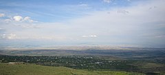
A view of Byurakan village (foreground) in the Aragatsotn region of Armenia as seen from the village of Tegher. Just above it is the town of Ashtarak; and in the background is the city of Yerevan.
A view of Byurakan village (foreground) in the Aragatsotn region of Armenia as seen from the village of Tegher. Just above it is the town of Ashtarak; and in the background is the city of Yerevan.


