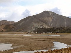
Bláhnjúkur
 Bláhnjúkur (2004 r.) | |
| Państwo | |
|---|---|
| Położenie | |
| Pasmo | |
| Wysokość | 940 m n.p.m. |
| 63°58′36″N 19°04′05″W/63,976800 -19,068100 | |
Bláhnjúkur – wulkan (940 m n.p.m.) położony w południowej Islandii. Ostatnia erupcja miała miejsce w 1477 r.
Linki zewnętrzne
- Zdjęcie Bláhnjúkur. [dostęp 2009-08-02].
Media użyte na tej stronie
U+25B2.svg
Black up-pointing triangle ▲, U+25B2 from Unicode-Block Geometric Shapes (25A0–25FF)
Black up-pointing triangle ▲, U+25B2 from Unicode-Block Geometric Shapes (25A0–25FF)
Bláhnjúkur.jpg
Autor: Christian Wirth, Licencja: CC BY-SA 2.5
Bláhnjúkur vulcano in Landmannalaugar, Iceland
Autor: Christian Wirth, Licencja: CC BY-SA 2.5
Bláhnjúkur vulcano in Landmannalaugar, Iceland
Iceland relief map.jpg
Autor:
Location map of Iceland
Autor:
- Iceland_location_map.svg: NordNordWest
- derivative work: Виктор В (talk)
Location map of Iceland


