Blackburn
.jpg) (c) Alexander P Kapp, CC BY-SA 2.0 | |
| Państwo | |
|---|---|
| Kraj | |
| Region | North West |
| Hrabstwo ceremonialne | Lancashire |
| Unitary authority | Blackburn with Darwen |
| Populacja (2001) • liczba ludności • gęstość | 105 085 4.291 os./km² |
| Nr kierunkowy | 01254 |
Położenie na mapie Lancashire  Contains Ordnance Survey data © Crown copyright and database right, CC BY-SA 3.0 | |
Położenie na mapie Wielkiej Brytanii  (c) Karte: NordNordWest, Lizenz: Creative Commons by-sa-3.0 de | |
Położenie na mapie Anglii  | |
| Strona internetowa | |
| Portal | |
Blackburn – miasto w Wielkiej Brytanii, w północno-zachodniej Anglii, w hrabstwie ceremonialnym Lancashire, w dystrykcie (unitary authority) Blackburn with Darwen. Leży 14,3 km na wschód od miasta Preston, 39,8 km na południowy wschód od miasta Lancaster i 296,6 km na północny zachód od Londynu[1]. W 2001 roku miasto liczyło 105 085 mieszkańców[2]. Blackburn jest wspomniana w Domesday Book (1086) jako Blacheburn[3].
Dane ogólne
Blackburn było już znane od XVIII wieku jako ośrodek przemysłu bawełnianego[4]. Obecnie rozwinięty przemysł maszynowy, elektrotechniczny, elektroniczny, chemiczny oraz spożywczy[4]. Muzeum włókiennictwa.
Zabytki
- Anglikańska katedra z 1826 roku
Sport
- Piłkarski klub Blackburn Rovers
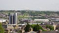
Centrum z górującym budynkiem Urzędu Miasta
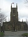
Katedra w Blackburn

Ratusz

Stacja kolejowa

Pomnik królowej Wiktorii

Budynek straży pożarnej

Szeregowa zabudowa
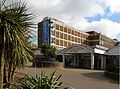
Blackburn College
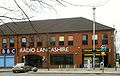
BBC Radio Lancashire

Budynek byłej poczty, obecnie pub

Współpraca
Zobacz też
- Blackburn (stacja kolejowa)
Przypisy
- ↑ Distance from BLACKBURN [SD682279] (ang.). GENUKI. [dostęp 2016-05-07].
- ↑ KS01 Usual resident population: Census 2001, Key Statistics for urban areas (ang.). Office for National Statistics. [dostęp 2016-05-07]. [zarchiwizowane z tego adresu (2004-07-23)].
- ↑ Lancashire A-L (ang.). The Domesday Book online. [dostęp 2016-05-07].
- ↑ a b Blackburn, [w:] Encyklopedia PWN [online] [dostęp 2021-10-17].
Media użyte na tej stronie
(c) Karte: NordNordWest, Lizenz: Creative Commons by-sa-3.0 de
Location map of the United Kingdom


Flag of England. Saint George's cross (a red cross on a white background), used as the Flag of England, the Italian city of Genoa and various other places.
.svg)


Autor: KGGucwa, Licencja: CC BY-SA 3.0
The Town Hall and Town Hall Extension in Blackburn, Lancashire, England, the UK.

Blackburn town centre from Shear Brow area

Autor: KGGucwa, Licencja: CC BY-SA 3.0
BBC Radio Lancashire, Blackburn, Lancashire, England, the UK.

Autor: KGGucwa, Licencja: CC BY-SA 3.0
The Postal Order in Blackburn, Lancashire, England, the UK.

Autor: KGGucwa, Licencja: CC BY-SA 3.0
The Fire Station in Blackburn, Lancashire, England, the UK.
(c) Alexander P Kapp, CC BY-SA 2.0
Blackburn Town Hall, Blackburn, Lancashire, England.

Autor: KGGucwa, Licencja: CC BY-SA 3.0
Dachy domów w Blackburn. Na pierwszym planie budynek straży pożarnej.

Autor: KGGucwa, Licencja: CC BY-SA 3.0
Blackburn College, Blackburn, Lancashire, England, the UK.

Autor: Autor nie został podany w rozpoznawalny automatycznie sposób. Założono, że to TreveX (w oparciu o szablon praw autorskich)., Licencja: CC-BY-SA-3.0
Blackburn Cathedral, Blackburn, Lancashire.

Autor: KGGucwa, Licencja: CC BY-SA 3.0
The railway station in Blackburn, Lancashire.
Contains Ordnance Survey data © Crown copyright and database right, CC BY-SA 3.0
Map of Lancashire, UK with the following information shown:
- Administrative borders
- Coastline, lakes and rivers
- Roads and railways
- Urban areas
Equirectangular map projection on WGS 84 datum, with N/S stretched 165%
Geographic limits:
- West: 3.13W
- East: 2.03W
- North: 54.25N
- South: 53.47N