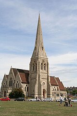
Blackheath (Londyn)
| ||||
 Kościół Wszystkich Świętych | ||||
| Państwo | ||||
|---|---|---|---|---|
| Kraj | ||||
| Region | Wielki Londyn | |||
| Miasto | Londyn | |||
| Gmina | Greenwich Lewisham | |||
Położenie na mapie Wielkiego Londynu Contains Ordnance Survey data © Crown copyright and database right, CC BY-SA 3.0 | ||||
Położenie na mapie Wielkiej Brytanii (c) Karte: NordNordWest, Lizenz: Creative Commons by-sa-3.0 de | ||||
| 51°28′12″N 0°00′32″E/51,470000 0,009000 | ||||
| Portal | ||||
Blackheath – jedna z dzielnic Londynu na pograniczu gmin London Borough of Lewisham i Royal Borough of Greenwich. W roku 2012 liczyła 25 116 mieszkańców[1].
Osoby związane z dzielnicą Blackheath
- John Vanbrugh (1664–1726), architekt i dramaturg
- Karolina Brunszwicka (1768–1821), królowa
- Elizabeth Garrett Anderson (1836–1937), pierwsza lekarka w Wielkiej Brytanii
- Aston Webb (1849–1930), architekt
- Francis Bourne (1861–1935), kardynał
Przypisy
Media użyte na tej stronie
Contains Ordnance Survey data © Crown copyright and database right, CC BY-SA 3.0
Map of Greater London, UK with the following information shown:
- Administrative borders
- Coastline, lakes and rivers
- Roads and railways
- Urban areas
The data includes both primary routes and railway lines.
Equirectangular map projection on WGS 84 datum, with N/S stretched 160%
Geographic limits:
- West: 0.57W
- East: 0.37E
- North: 51.72N
- South: 51.25N
(c) Karte: NordNordWest, Lizenz: Creative Commons by-sa-3.0 de
Location map of the United Kingdom
Flag of England. Saint George's cross (a red cross on a white background), used as the Flag of England, the Italian city of Genoa and various other places.
All Saints parish church, Blackheath, London, seen from the southwest


