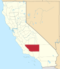
Blackwells Corner
| ||||
| ||||
 | ||||
| Państwo | ||||
| Stan | ||||
| Hrabstwo | Kern | |||
| Wysokość | 198 m n.p.m. | |||
| Strefa czasowa | UTC-08:00 UTC-07:00 | |||
| Portal | ||||
Blackwells Corner – obszar niemunicypalny w Kern County, w Kalifornii (Stany Zjednoczone), na wysokości 198 m.
Linki zewnętrzne
Media użyte na tej stronie
Autor: NordNordWest, Licencja: CC BY 3.0
Location map of California, USA
Autor: Uwe Dedering, Licencja: CC BY-SA 3.0
Location map of the USA (without Hawaii and Alaska).
EquiDistantConicProjection:
Central parallel:
* N: 37.0° N
Central meridian:
* E: 96.0° W
Standard parallels:
* 1: 32.0° N
* 2: 42.0° N
Made with Natural Earth. Free vector and raster map data @ naturalearthdata.com.
Formulas for x and y:
x = 50.0 + 124.03149777329222 * ((1.9694462586094064-({{{2}}}* pi / 180))
      * sin(0.6010514667026994 * ({{{3}}} + 96) * pi / 180))
y = 50.0 + 1.6155950752393982 * 124.03149777329222 * 0.02613325650382181
      - 1.6155950752393982  * 124.03149777329222 *
     (1.3236744353715044  - (1.9694462586094064-({{{2}}}* pi / 180))
      * cos(0.6010514667026994 * ({{{3}}} + 96) * pi / 180))
The flag of Navassa Island is simply the United States flag. It does not have a "local" flag or "unofficial" flag; it is an uninhabited island. The version with a profile view was based on Flags of the World and as a fictional design has no status warranting a place on any Wiki. It was made up by a random person with no connection to the island, it has never flown on the island, and it has never received any sort of recognition or validation by any authority. The person quoted on that page has no authority to bestow a flag, "unofficial" or otherwise, on the island.
Flag of California. This version is designed to accurately depict the standard print of the bear as well as adhere to the official flag code regarding the size, position and proportion of the bear, the colors of the flag, and the position and size of the star.
Autor: Amin Eshaiker, Licencja: CC BY-SA 3.0
Texaco gas station and mini-market at 17191 Highway 46, Blackwells Corner, California. Blackwells Corner was originally established by local machinist George Blackwell as a service station in 1921 and eventually included a cafe and grocery store. The location became famous as the last reported stop of actor James Dean prior to his tragic death in a fatal car accident just down the highway. A fire destroyed the station in 1968, however the establishment was soon re-built. The building was later remodeled in the 2000's to include modern fixtures. View from the northwestern corner of the West Side Highway (California State Route 33) and Paso Robles Highway (California State Route 46) intersection, looking southeast.
This photograph was taken with an Olympus E-510 DSLR camera and edited (brightness, contrast, saturation, crop, roatate) using ArcSoft PhotoStudio 5.5)
Locator map showing Kern County — in central and southern California.


