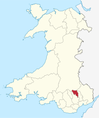
Blaenau Gwent
| hrabstwo miejskie | |||
 | |||
| |||
| Państwo | |||
|---|---|---|---|
| Księstwo | |||
| Siedziba | |||
| Powierzchnia | 109 km² | ||
| Populacja • liczba ludności |
| ||
| • gęstość | 643 os./km² | ||
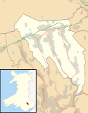
Położenie na mapie Walii | |||
| Portal | |||
Blaenau Gwent (wymowa angielska: [ˌblaɪnaɪ ˈɡwɛnt]; wymowa walijska: [ˈbləɨ.naɨ ˈɡwɛnt]) – hrabstwo miejskie w południowej Walii. Od wschodu graniczy z Monmouthshire i Torfaen, Caerphilly od zachodu oraz Powys od północy.
Miejscowości
Na terenie hrabstwa znajdują się następujące miejscowości[1][2] (w nawiasach liczba ludności w 2011[3]):
- Ebbw Vale (18 095)
- Tredegar (14 855)
- Abertillery (10 946)
- Brynmawr (5530)
- Blaina (4808)
- Nantyglo (4635)
- Llanhilleth (2990)
- Cwm (2739)
- Waun-Lwyd (1556)
Mapa
Przypisy
- ↑ Office for National Statistics: Built-up Area to Local Authority District (December 2011) Lookup in England and Wales (ang.). W: Open Geography Portal [on-line]. [dostęp 2022-06-05].
- ↑ Office for National Statistics: Built-up Area Sub Divisions (December 2011) Boundaries (ang.). W: Open Geography Potal [on-line]. [dostęp 2022-06-05].
- ↑ Office for National Statistics: KS101EW - Usual resident population (ang.). W: 2011 Census [on-line]. Nomis – Official labour market statistics, 2013-02-12. [dostęp 2022-06-05].
Media użyte na tej stronie
Contains Ordnance Survey data © Crown copyright and database right, CC BY-SA 3.0
Blank map of Blaenau Gwent, UK with the following information shown:
- Administrative borders
- Coastline, lakes and rivers
- Roads and railways
- Urban areas
Equirectangular map projection on WGS 84 datum, with N/S stretched 160%
Geographic limits:
- West: 3.35W
- East: 3.10W
- North: 51.85N
- South: 51.65N
Photograph from the Martin Ridley Collection, which documents the towns and villages of South Wales c.1900-1910
Autor: TUBS
Location of unitary authority area Blaenau Gwent in Wales in Wales.


