Bloemendaal
| |||||
 | |||||
| Państwo | |||||
|---|---|---|---|---|---|
| Prowincja | |||||
| Siedziba | Bloemendaal | ||||
| Burmistrz | Ruud Nederveen (2014)[1] | ||||
| Powierzchnia | 45,18 km² | ||||
| Populacja (2013) • liczba ludności | 22.172 | ||||
| • gęstość | 558 os./km² | ||||
| Numer kierunkowy | 023 | ||||
| Kod pocztowy | 2050-2061, 2110-2114, 2120, 2121 | ||||
Położenie na mapie.svg) | |||||
Bloemendaal – gmina i miejscowość w Holandii w prowincji Holandia Północna, u wybrzeży Morza Północnego. Powierzchnia gminy wynosi 45,18 km², zamieszkuje ją 22 172 ludzi (stan z roku 2013). Znajduje się tu cmentarz Eerebegraafplaats Bloemendaal, będący miejscem pochówku 373 żołnierzy ruchu oporu poległych w II wojnie światowej.
Na terenie gminy znajduje się też Park Narodowy Bloemendaal obejmujący krajobraz nadmorskich wydm.
Z Bloemendaal pochodzi Ellen Hoog, holenderska hokeistka na trawie.
Miejscowości
Wsie
- Aerdenhout
- Bentveld
- Bloemendaal
- Overveen
- Vogelenzangstraat
- Bennebroek
Przysiółki
- Bloemendaal aan Zee
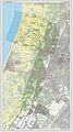
Mapa gminy

Park Narodowy Bloemendaal – droga przez wydmy
Zobacz też
Przypisy
- ↑ bloemendaal.nl: Samenstelling college van burgemeester en wethouders 2014 – 2018 (niderl.). [dostęp 2014-07-19]. [zarchiwizowane z tego adresu (2014-08-11)].
![]()
Media użyte na tej stronie


Coat of arms of the Dutch municipality of Bloemendaal.
photo of the Bloemendaal town hall in Overveen.

Autor: Janwillemvanaalst, Licencja: CC BY-SA 3.0
Topografische kaart van gemeente Bloemendaal (2013).
Samengesteld door user:janwillemvanaalst op basis van de GML open geodata van de BRT/Top10NL (basisregistratie Topografie, Kadaster 2011), vrijgegeven door Kadaster onder de Creative Commons BY licentie. Additionele gegevens uit BAG (8 juli 2013), uit de Open Street Map (9 juli 2013) en uit de Risicokaart. Peildatum kaartbeeld: 9 juli 2013.
Samenstelling en kleurenschema: Jan-Willem van Aalst, met QuantumGIS en Photoshop. Zie ook de Legenda.
Autor: Michiel1972 (talk) 22:30, 24 January 2009 (UTC), Licencja: CC BY-SA 3.0
- Location maps for the 441 municipalities in the Netherlands. Boundaries 1/1/2009
- Automatically generated with script
- File name contains "Municipality code" (CBS-code) as specified in: [1]
- Created in svg using coordinate data derived from ESRI data published by Centraal Bureau voor de Statistiek, Voorburg/Heerlen. ([2])
- Color coding and original design (slightly adpated by me) by user Mtcv (2006/2007) ([3])
 |
Właściciel autorskich praw majątkowych do tego pliku, Centraal Bureau voor de Statistiek, zezwala każdemu wykorzystać go w dowolnym celu, pod warunkiem, że wykorzystujący wyraźnie wskaże autora. Redystrybucja, wykonywanie prac pochodnych, użycie komercyjne oraz każde inne są dozwolone. |
|
Uznanie autorstwa: Centraal Bureau voor de Statistiek
|

Flag of the Dutch municipality of Bloemendaal between 1981 and 2019

Bloemendaal National Park, a road among dunes, Holland